Claremorris geodata
Claremorris (Connaught) is a populated place; located in Ireland in Europe/Dublin (GMT+1) time zone. With population of 3,412 people, there are 177 cities with bigger population in this country. Compared to other cities in Ireland, 78.7% of cities are located further ↓South; 89.4% of cities are located further →East and 61.3% of cities have lower elevation than Claremorris. Note1


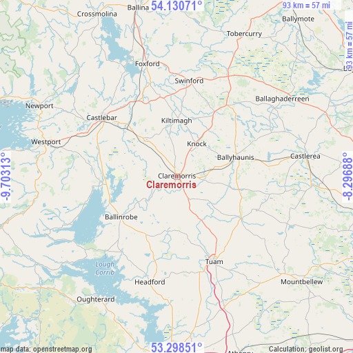
Claremorris GPS coordinates[2]
53° 43' 0.012" North, 9° 0' 0" West
| Map corner | latitude | longitude |
|---|---|---|
| Upper-left | 54.13071°, | -9.70313° |
| Center: | 53.71667°, | -9° |
| Lower-right: | 53.29851°, | -8.29688° |
| Map W x H: | 92.5×92.5 km | = 57.5×57.5mi |
| max Lat: | 55.25° ⇑21.3% North |
| Claremorris: | 53.71667° |
| min Lat: | ⇓78.7% South 51.52487° |
| min Long | Claremorris | max Long |
| -10.26889° | -9° | -6.04944° |
| W 10.6%⇐ | ⇒89.4% E |
Elevation
Elevation of Claremorris is 61 m = 200 ft, and this is 6.5 m = 21 ft above average elevation for this country.
| Max E: |
262 m = 860 ft | 38.7% |
| Claremorris | 61 m 200 ft | |
| Avg. | 54.5 m = 179 ft | |
Min E: |
0 m = 0 ft | 61.3% |
See also: Ireland elevation on elevation.city.
Geographical zone
Claremorris is located in North temperate zone (between Tropic of Cancer and the Arctic Circle). Distance of this North polar circle is 1428.4 km =887.6 mi to North.| Distance of | km | miles | from Claremorris |
|---|---|---|---|
| North Pole | 4034.3 | 2506.8 | to North |
| Arctic Circle | 1428.4 | 887.6 | to North |
| Tropic Cancer | 3366.8 | 2092 | to South |
| Equator | 5972.7 | 3711.3 | to South |


Nearby cities:
15 places around Claremorris: (largest is in red/bold)
• Balla
12.8 km =8 mi,  318°
318°
• Ballaghaderreen
34.1 km =21.2 mi,  53°
53°
• Ballinrobe
17.9 km =11.1 mi,  238°
238°
• Ballyhaunis
16.3 km =10.1 mi,  70°
70°
• Castlebar
24.7 km =15.3 mi,  306°
306°
• Castlerea
33.3 km =20.7 mi,  80°
80°
• Charlestown
30.7 km =19.1 mi,  26°
26°
• Corrofin
32.2 km =20 mi,  164°
164°
• Dunmore
20.8 km =12.9 mi,  122°
122°
• Foxford
30.3 km =18.8 mi,  345°
345°
• Headford
28.6 km =17.8 mi,  193°
193°
• Kiltamagh
14.8 km =9.2 mi,  0°
0°
• Knock
9.7 km =6 mi, 32°
• Swinford
26.2 km =16.3 mi,  7°
7°
• Tuam
24.3 km =15.1 mi, 156°
Sources, notices
• [Note1] Compared only with cities in Ireland existing in our database
• [Src1] Map data: © OpenStreetMap contributors (CC-BY-SA)
• [Src2] Other city data from geonames.org with taken over terms of usage.
• [Src3] Geographical zone / Annual Mean Temperature by Robert A. Rohde @ Wikipedia
