Howth geodata
Howth (Leinster) is a populated place; located in Ireland in Europe/Dublin (GMT+1) time zone. With population of 4,574 people, there are 143 cities with bigger population in this country. Compared to other cities in Ireland, 64.7% of cities are located further ↓South; 99.2% of cities are located further ←West and 80.5% of cities have higher elevation than Howth. Note1


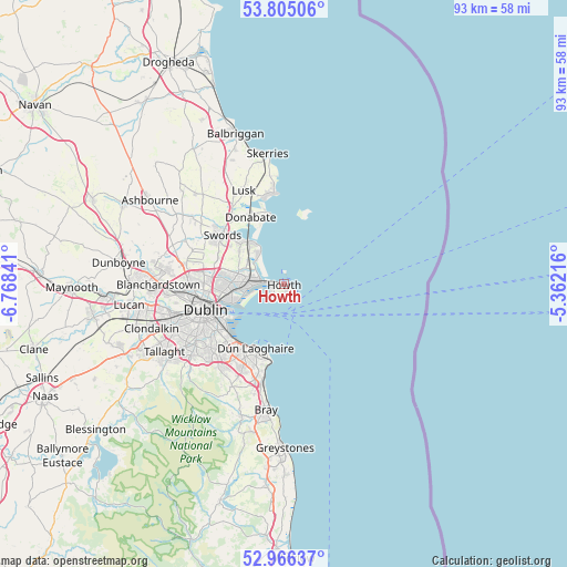
Howth GPS coordinates[2]
53° 23' 16.008" North, 6° 3' 55.008" West
| Map corner | latitude | longitude |
|---|---|---|
| Upper-left | 53.80506°, | -6.76841° |
| Center: | 53.38778°, | -6.06528° |
| Lower-right: | 52.96637°, | -5.36216° |
| Map W x H: | 93.3×93.3 km | = 58×58mi |
| max Lat: | 55.25° ⇑35.3% North |
| Howth: | 53.38778° |
| min Lat: | ⇓64.7% South 51.52487° |
| min Long | Howth | max Long |
| -10.26889° | -6.06528° | -6.04944° |
| W 99.2%⇐ | ⇒0.8% E |
Elevation
Elevation of Howth is 17 m = 56 ft, and this is 37.5 m = 123 ft below average elevation for this country.
| Max E: |
262 m = 860 ft | 80.5% |
| Avg. | 54.5 m = 179 ft | |
| Howth | 17 m = 56 ft | |
Min E: |
0 m = 0 ft | 19.5% |
See also: Ireland elevation on elevation.city.
Geographical zone
Howth is located in North temperate zone (between Tropic of Cancer and the Arctic Circle). Distance of this North polar circle is 1465 km =910.3 mi to North.| Distance of | km | miles | from Howth |
|---|---|---|---|
| North Pole | 4070.9 | 2529.5 | to North |
| Arctic Circle | 1465 | 910.3 | to North |
| Tropic Cancer | 3330.2 | 2069.3 | to South |
| Equator | 5936.2 | 3688.6 | to South |


Nearby cities:
15 places around Howth: (largest is in red/bold)
• Artane
9.8 km =6.1 mi,  269°
269°
• Baldoyle
4.2 km =2.6 mi,  288°
288°
• Bayside
5 km =3.1 mi, 271°
• Beaumont
10.7 km =6.6 mi, 269°
• Bonnybrook
9.5 km =5.9 mi,  277°
277°
• Coolock
8.9 km =5.5 mi, 270°
• Darndale
8.3 km =5.2 mi, 279°
• Dollymount
8 km =5 mi,  251°
251°
• Donaghmede
6.5 km =4 mi, 280°
• Donnycarney
9.7 km =6 mi,  260°
260°
• Killester
9.4 km =5.8 mi, 260°
• Malahide
9.2 km =5.7 mi,  319°
319°
• Portmarnock
6.2 km =3.9 mi,  309°
309°
• Raheny
7.7 km =4.8 mi, 269°
• Sutton
3 km =1.9 mi, 273°
Sources, notices
• [Note1] Compared only with cities in Ireland existing in our database
• [Src1] Map data: © OpenStreetMap contributors (CC-BY-SA)
• [Src2] Other city data from geonames.org with taken over terms of usage.
• [Src3] Geographical zone / Annual Mean Temperature by Robert A. Rohde @ Wikipedia
