Nazareth geodata
Nazareth (Northern District) is a seat of a first-order administrative division; located in Israel in Asia/Jerusalem (GMT+3) time zone. With population of 64,800 people, there are 23 cities with bigger population in this country. Compared to other cities in Israel, 65.7% of cities are located further ↓South; 77.5% of cities are located further ←West and 83.4% of cities have lower elevation than Nazareth. Note1


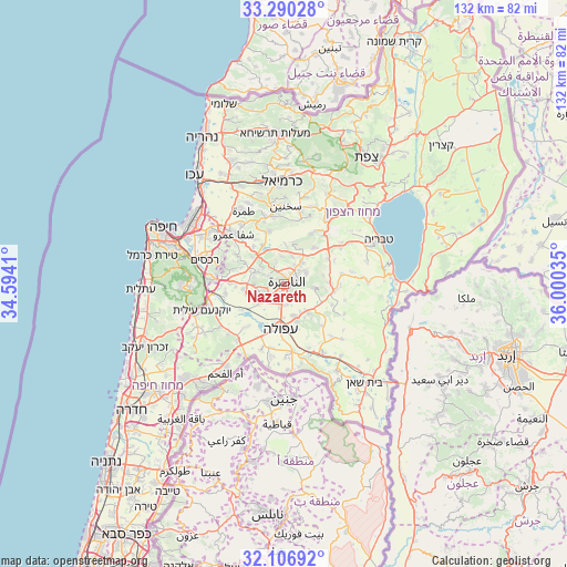
Nazareth GPS coordinates[2]
32° 42' 2.016" North, 35° 17' 49.992" East
| Map corner | latitude | longitude |
|---|---|---|
| Upper-left | 33.29028°, | 34.5941° |
| Center: | 32.70056°, | 35.29722° |
| Lower-right: | 32.10692°, | 36.00035° |
| Map W x H: | 131.6×131.6 km | = 81.8×81.8mi |
| max Lat: | 33.27918° ⇑34.3% North |
| Nazareth: | 32.70056° |
| min Lat: | ⇓65.7% South 29.55805° |
| min Long | Nazareth | max Long |
| 34.57149° | 35.29722° | 35.81084° |
| W 77.5%⇐ | ⇒22.5% E |
Elevation
Elevation of Nazareth is 504 m = 1654 ft, and this is 280.6 m = 921 ft above average elevation for this country.
| Max E: |
988 m = 3241 ft | 16.6% |
| Nazareth | 504 m 1654 ft | |
| Avg. | 223.4 m = 733 ft | |
Min E: |
-380 m = -1247 ft | 83.4% |
See also: Nazareth elevation on elevation.city.
Geographical zone
Nazareth is located in North temperate zone (between Tropic of Cancer and the Arctic Circle). Distance of this Northern Tropic circle is 1030 km =640 mi to South.| Distance of | km | miles | from Nazareth |
|---|---|---|---|
| North Pole | 6371.1 | 3958.8 | to North |
| Arctic Circle | 3765.2 | 2339.6 | to North |
| Tropic Cancer | 1030 | 640 | to South |
| Equator | 3636 | 2259.3 | to South |


Nearby cities:
15 places around Nazareth: (largest is in red/bold)
• Afula
10.2 km =6.3 mi,  184°
184°
• Bīr el Maksūr
11.1 km =6.9 mi,  320°
320°
• Dabbūrīya
7 km =4.3 mi,  97°
97°
• Er Reina
3.1 km =1.9 mi,  35°
35°
• Iksāl
3.2 km =2 mi,  130°
130°
• Kafr Kannā
6.6 km =4.1 mi, 39°
• Kefar Tavor
11.7 km =7.3 mi, 97°
• Migdal Ha‘Emeq
6 km =3.7 mi,  243°
243°
• Nein
9.2 km =5.7 mi,  148°
148°
• Rumat Heib
8.6 km =5.3 mi,  5°
5°
• Shibli
8.9 km =5.5 mi,  94°
94°
• Sūlam
11.1 km =6.9 mi,  161°
161°
• Timrat
6.9 km =4.3 mi,  272°
272°
• Ẕippori
5.2 km =3.2 mi,  342°
342°
• ‘Uzeir
10.6 km =6.6 mi,  16°
16°
In other languages:
- In Spanish: Nazaret
- In German: Nazaret
- In Italian: Nazaret
- In Russian: Назарет
- In Chinese: 拿撒勒
Sources, notices
• [Note1] Compared only with cities in Israel existing in our database
• [Src1] Map data: © OpenStreetMap contributors (CC-BY-SA)
• [Src2] Other city data from geonames.org with taken over terms of usage.
• [Src3] Geographical zone / Annual Mean Temperature by Robert A. Rohde @ Wikipedia
