Shibli geodata
Shibli (Northern District) is a populated place; located in Israel in Asia/Jerusalem (GMT+3) time zone. With population of 4,800 people, there are 110 cities with bigger population in this country. Compared to other cities in Israel, 65.1% of cities are located further ↓South; 89.9% of cities are located further ←West and 63.9% of cities have lower elevation than Shibli. Note1


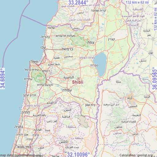
Shibli GPS coordinates[2]
32° 41' 40.704" North, 35° 23' 33.072" East
| Map corner | latitude | longitude |
|---|---|---|
| Upper-left | 33.2844°, | 34.6894° |
| Center: | 32.69464°, | 35.39252° |
| Lower-right: | 32.10096°, | 36.09565° |
| Map W x H: | 131.6×131.6 km | = 81.8×81.8mi |
| max Lat: | 33.27918° ⇑34.9% North |
| Shibli: | 32.69464° |
| min Lat: | ⇓65.1% South 29.55805° |
| min Long | Shibli | max Long |
| 34.57149° | 35.39252° | 35.81084° |
| W 89.9%⇐ | ⇒10.1% E |
Elevation
Elevation of Shibli is 234 m = 768 ft, and this is 10.6 m = 35 ft above average elevation for this country.
| Max E: |
988 m = 3241 ft | 36.1% |
| Shibli | 234 m 768 ft | |
| Avg. | 223.4 m = 733 ft | |
Min E: |
-380 m = -1247 ft | 63.9% |
See also: Israel elevation on elevation.city.
Geographical zone
Shibli is located in North temperate zone (between Tropic of Cancer and the Arctic Circle). Distance of this Northern Tropic circle is 1029.4 km =639.6 mi to South.| Distance of | km | miles | from Shibli |
|---|---|---|---|
| North Pole | 6371.8 | 3959.3 | to North |
| Arctic Circle | 3765.9 | 2340 | to North |
| Tropic Cancer | 1029.4 | 639.6 | to South |
| Equator | 3635.3 | 2258.9 | to South |


Nearby cities:
15 places around Shibli: (largest is in red/bold)
• Bu‘eina
12.7 km =7.9 mi,  348°
348°
• Dabbūrīya
2 km =1.2 mi,  263°
263°
• Er Reina
7.8 km =4.8 mi,  294°
294°
• Iksāl
6.6 km =4.1 mi, 257°
• Kafr Kammā
5.4 km =3.4 mi,  56°
56°
• Kafr Kannā
7.4 km =4.6 mi,  320°
320°
• Kafr Miṣr
6.1 km =3.8 mi,  153°
153°
• Kefar Tavor
2.8 km =1.7 mi,  108°
108°
• Nazareth
8.9 km =5.5 mi,  274°
274°
• Nein
8.2 km =5.1 mi,  209°
209°
• Rumat Heib
12.3 km =7.6 mi, 318°
• Sūlam
11.3 km =7 mi, 209°
• Yavne’el
10.5 km =6.5 mi,  83°
83°
• Ẕippori
11.9 km =7.4 mi,  298°
298°
• ‘Uzeir
12.3 km =7.6 mi,  331°
331°
Sources, notices
• [Note1] Compared only with cities in Israel existing in our database
• [Src1] Map data: © OpenStreetMap contributors (CC-BY-SA)
• [Src2] Other city data from geonames.org with taken over terms of usage.
• [Src3] Geographical zone / Annual Mean Temperature by Robert A. Rohde @ Wikipedia
