Kafr Miṣr geodata
Kafr Miṣr (Northern District) is a populated place; located in Israel in Asia/Jerusalem (GMT+3) time zone. With population of 2,400 people, there are 135 cities with bigger population in this country. Compared to other cities in Israel, 60.9% of cities are located further ↓South; 92.3% of cities are located further ←West and 51.5% of cities have lower elevation than Kafr Miṣr. Note1


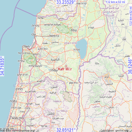
Kafr Miṣr GPS coordinates[2]
32° 38' 42.756" North, 35° 25' 17.292" East
| Map corner | latitude | longitude |
|---|---|---|
| Upper-left | 33.23529°, | 34.71835° |
| Center: | 32.64521°, | 35.42147° |
| Lower-right: | 32.05121°, | 36.1246° |
| Map W x H: | 131.7×131.7 km | = 81.8×81.8mi |
| max Lat: | 33.27918° ⇑39.1% North |
| Kafr Miṣr: | 32.64521° |
| min Lat: | ⇓60.9% South 29.55805° |
| min Long | Kafr Miṣr | max Long |
| 34.57149° | 35.42147° | 35.81084° |
| W 92.3%⇐ | ⇒7.7% E |
Elevation
Elevation of Kafr Miṣr is 122 m = 400 ft, and this is 101.4 m = 333 ft below average elevation for this country.
| Max E: |
988 m = 3241 ft | 48.5% |
| Avg. | 223.4 m = 733 ft | |
| Kafr Miṣr | 122 m = 400 ft | |
Min E: |
-380 m = -1247 ft | 51.5% |
See also: Israel elevation on elevation.city.
Geographical zone
Kafr Miṣr is located in North temperate zone (between Tropic of Cancer and the Arctic Circle). Distance of this Northern Tropic circle is 1023.9 km =636.2 mi to South.| Distance of | km | miles | from Kafr Miṣr |
|---|---|---|---|
| North Pole | 6377.3 | 3962.7 | to North |
| Arctic Circle | 3771.4 | 2343.4 | to North |
| Tropic Cancer | 1023.9 | 636.2 | to South |
| Equator | 3629.8 | 2255.5 | to South |


Nearby cities:
15 places around Kafr Miṣr: (largest is in red/bold)
• Afula
13 km =8.1 mi,  252°
252°
• Bet She’an
17.9 km =11.1 mi,  156°
156°
• Dabbūrīya
7.1 km =4.4 mi,  318°
318°
• Er Reina
13.1 km =8.1 mi,  311°
311°
• Iksāl
10 km =6.2 mi,  293°
293°
• Kafr Kammā
8.7 km =5.4 mi,  12°
12°
• Kafr Kannā
13.5 km =8.4 mi,  326°
326°
• Kefar Tavor
4.6 km =2.9 mi,  359°
359°
• Migdal Ha‘Emeq
17.3 km =10.7 mi,  281°
281°
• Nazareth
13.2 km =8.2 mi,  297°
297°
• Nein
7 km =4.3 mi,  256°
256°
• Shibli
6.1 km =3.8 mi, 333°
• Sūlam
9.3 km =5.8 mi,  241°
241°
• Yavne’el
10.3 km =6.4 mi,  48°
48°
• Ẕippori
17.3 km =10.7 mi, 310°
Sources, notices
• [Note1] Compared only with cities in Israel existing in our database
• [Src1] Map data: © OpenStreetMap contributors (CC-BY-SA)
• [Src2] Other city data from geonames.org with taken over terms of usage.
• [Src3] Geographical zone / Annual Mean Temperature by Robert A. Rohde @ Wikipedia
