Vasco da Gama geodata
Vasco da Gama (Goa) is a populated place; located in India in Asia/Kolkata (GMT+5.5) time zone. With population of 100,485 people, there are 438 cities with bigger population in this country. Compared to other cities in India, 80.3% of cities are located further ↑North; 91.1% of cities are located further →East and 99% of cities have higher elevation than Vasco da Gama. Note1


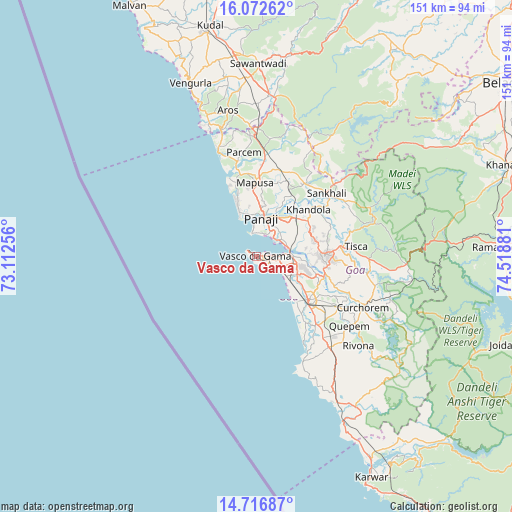
Vasco da Gama GPS coordinates[2]
15° 23' 45.06" North, 73° 48' 56.448" East
| Map corner | latitude | longitude |
|---|---|---|
| Upper-left | 16.07262°, | 73.11256° |
| Center: | 15.39585°, | 73.81568° |
| Lower-right: | 14.71687°, | 74.51881° |
| Map W x H: | 150.7×150.7 km | = 93.6×93.6mi |
| max Lat: | 34.9274° ⇑80.3% North |
| Vasco da Gama: | 15.39585° |
| min Lat: | ⇓19.7% South 8.09008° |
| min Long | Vasco da Gama | max Long |
| 68.82655° | 73.81568° | 96.81° |
| W 8.9%⇐ | ⇒91.1% E |
Elevation
Elevation of Vasco da Gama is 7 m = 23 ft, and this is 288.6 m = 947 ft below average elevation for this country.
| Max E: |
3681 m = 12077 ft | 99% |
| Avg. | 295.6 m = 970 ft | |
| Vasco da Gama | 7 m = 23 ft | |
Min E: |
1 m = 3 ft | 1% |
See also: Vasco da Gama elevation on elevation.city.
Geographical zone
Vasco da Gama is located in North Torrid zone (between Equator and Tropic of Cancer). Distance of this Northern Tropic circle is 894.1 km =555.6 mi to North.| Distance of | km | miles | from Vasco da Gama |
|---|---|---|---|
| North Pole | 8295.2 | 5154.4 | to North |
| Arctic Circle | 5689.3 | 3535.2 | to North |
| Tropic Cancer | 894.1 | 555.6 | to North |
| Equator | 1711.9 | 1063.7 | to South |


Nearby cities:
15 places around Vasco da Gama: (largest is in red/bold)
• Bambolim
8.5 km =5.3 mi,  28°
28°
• Bandora
17.8 km =11.1 mi,  85°
85°
• Calangute
17.7 km =11 mi,  338°
338°
• Candolim
14.7 km =9.1 mi, 337°
• Chicalim
2.9 km =1.8 mi,  84°
84°
• Colva
17.3 km =10.7 mi,  138°
138°
• Cortalim
10 km =6.2 mi, 85°
• Goa Velha
9.2 km =5.7 mi,  54°
54°
• Mormugao
0.8 km =0.5 mi,  186°
186°
• Panaji
11.2 km =7 mi,  5°
5°
• Saligao
17.7 km =11 mi,  351°
351°
• Sancoale
9.6 km =6 mi,  101°
101°
• Serula
17.1 km =10.6 mi, 9°
• Sinquerim
13 km =8.1 mi, 337°
• Taleigao
8.4 km =5.2 mi, 12°
Sources, notices
• [Note1] Compared only with cities in India existing in our database
• [Src1] Map data: © OpenStreetMap contributors (CC-BY-SA)
• [Src2] Other city data from geonames.org with taken over terms of usage.
• [Src3] Geographical zone / Annual Mean Temperature by Robert A. Rohde @ Wikipedia
