Mormugao geodata
Mormugao (Goa) is a populated place; located in India in Asia/Kolkata (GMT+5.5) time zone. With population of 102,345 people, there are 428 cities with bigger population in this country. Compared to other cities in India, 80.5% of cities are located further ↑North; 91.1% of cities are located further →East and 85.8% of cities have higher elevation than Mormugao. Note1


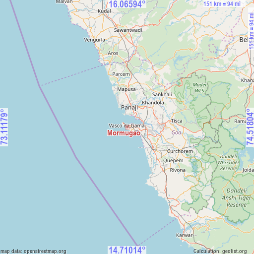
Mormugao GPS coordinates[2]
15° 23' 20.904" North, 73° 48' 53.676" East
| Map corner | latitude | longitude |
|---|---|---|
| Upper-left | 16.06594°, | 73.11179° |
| Center: | 15.38914°, | 73.81491° |
| Lower-right: | 14.71014°, | 74.51804° |
| Map W x H: | 150.8×150.8 km | = 93.7×93.7mi |
| max Lat: | 34.9274° ⇑80.5% North |
| Mormugao: | 15.38914° |
| min Lat: | ⇓19.5% South 8.09008° |
| min Long | Mormugao | max Long |
| 68.82655° | 73.81491° | 96.81° |
| W 8.9%⇐ | ⇒91.1% E |
Elevation
Elevation of Mormugao is 28 m = 92 ft, and this is 267.6 m = 878 ft below average elevation for this country.
| Max E: |
3681 m = 12077 ft | 85.8% |
| Avg. | 295.6 m = 970 ft | |
| Mormugao | 28 m = 92 ft | |
Min E: |
1 m = 3 ft | 14.2% |
See also: Mormugao elevation on elevation.city.
Geographical zone
Mormugao is located in North Torrid zone (between Equator and Tropic of Cancer). Distance of this Northern Tropic circle is 894.8 km =556 mi to North.| Distance of | km | miles | from Mormugao |
|---|---|---|---|
| North Pole | 8295.9 | 5154.8 | to North |
| Arctic Circle | 5690.1 | 3535.7 | to North |
| Tropic Cancer | 894.8 | 556 | to North |
| Equator | 1711.1 | 1063.2 | to South |


Nearby cities:
15 places around Mormugao: (largest is in red/bold)
• Bambolim
9.2 km =5.7 mi,  26°
26°
• Bandora
18 km =11.2 mi,  83°
83°
• Benaulim
18.4 km =11.4 mi,  138°
138°
• Candolim
15.4 km =9.6 mi,  338°
338°
• Chicalim
3.1 km =1.9 mi,  70°
70°
• Colva
16.8 km =10.4 mi, 136°
• Cortalim
10.2 km =6.3 mi, 81°
• Goa Velha
9.7 km =6 mi,  51°
51°
• Panaji
11.9 km =7.4 mi,  5°
5°
• Queula
18.3 km =11.4 mi,  89°
89°
• Sancoale
9.6 km =6 mi,  97°
97°
• Serula
17.9 km =11.1 mi, 9°
• Sinquerim
13.6 km =8.5 mi, 338°
• Taleigao
9.1 km =5.7 mi, 12°
• Vasco da Gama
0.8 km =0.5 mi, 6°
Sources, notices
• [Note1] Compared only with cities in India existing in our database
• [Src1] Map data: © OpenStreetMap contributors (CC-BY-SA)
• [Src2] Other city data from geonames.org with taken over terms of usage.
• [Src3] Geographical zone / Annual Mean Temperature by Robert A. Rohde @ Wikipedia
