Vaikam geodata
Vaikam (Kerala) is a populated place; located in India in Asia/Kolkata (GMT+5.5) time zone. With population of 22,807 people, there are 1846 cities with bigger population in this country. Compared to other cities in India, 97.1% of cities are located further ↑North; 69.2% of cities are located further →East and 92.8% of cities have higher elevation than Vaikam. Note1


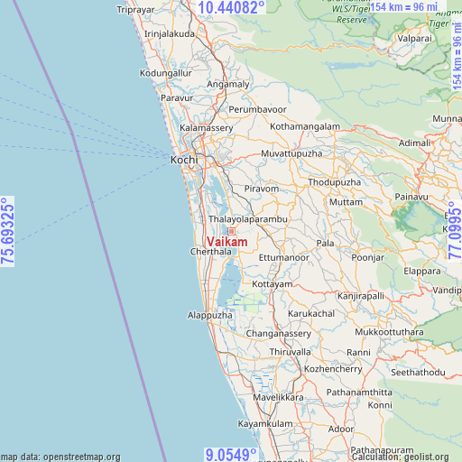
Vaikam GPS coordinates[2]
9° 44' 54.888" North, 76° 23' 46.932" East
| Map corner | latitude | longitude |
|---|---|---|
| Upper-left | 10.44082°, | 75.69325° |
| Center: | 9.74858°, | 76.39637° |
| Lower-right: | 9.0549°, | 77.0995° |
| Map W x H: | 154.1×154.1 km | = 95.8×95.8mi |
| max Lat: | 34.9274° ⇑97.1% North |
| Vaikam: | 9.74858° |
| min Lat: | ⇓2.9% South 8.09008° |
| min Long | Vaikam | max Long |
| 68.82655° | 76.39637° | 96.81° |
| W 30.8%⇐ | ⇒69.2% E |
Elevation
Elevation of Vaikam is 14 m = 46 ft, and this is 281.6 m = 924 ft below average elevation for this country.
| Max E: |
3681 m = 12077 ft | 92.8% |
| Avg. | 295.6 m = 970 ft | |
| Vaikam | 14 m = 46 ft | |
Min E: |
1 m = 3 ft | 7.2% |
See also: India elevation on elevation.city.
Geographical zone
Vaikam is located in North Torrid zone (between Equator and Tropic of Cancer). Distance of Equator is 1083.9 km =673.5 mi to South.| Distance of | km | miles | from Vaikam |
|---|---|---|---|
| North Pole | 8923.1 | 5544.6 | to North |
| Arctic Circle | 6317.2 | 3925.3 | to North |
| Tropic Cancer | 1522 | 945.7 | to North |
| Equator | 1083.9 | 673.5 | to South |


Nearby cities:
15 places around Vaikam: (largest is in red/bold)
• Alappuzha
29.8 km =18.5 mi,  194°
194°
• Aroor
16.8 km =10.4 mi,  323°
323°
• Arukutti
14.1 km =8.8 mi,  338°
338°
• Cherthala
9.8 km =6.1 mi,  223°
223°
• Cochin
26 km =16.2 mi, 324°
• Kalavoor
21.2 km =13.2 mi,  200°
200°
• Kottayam
22.6 km =14 mi,  142°
142°
• Kumbalam
19.9 km =12.4 mi,  332°
332°
• Kutiatodu
9 km =5.6 mi,  309°
309°
• Muvattupuzha
32.2 km =20 mi,  37°
37°
• Palackattumala
25.5 km =15.8 mi,  91°
91°
• Piravam
17.4 km =10.8 mi, 40°
• Rāmamangalam
23.5 km =14.6 mi,  28°
28°
• Shertallai
9.3 km =5.8 mi, 221°
• Vayalār
7.5 km =4.7 mi,  236°
236°
Sources, notices
• [Note1] Compared only with cities in India existing in our database
• [Src1] Map data: © OpenStreetMap contributors (CC-BY-SA)
• [Src2] Other city data from geonames.org with taken over terms of usage.
• [Src3] Geographical zone / Annual Mean Temperature by Robert A. Rohde @ Wikipedia
