Rāmamangalam geodata
Rāmamangalam (Kerala) is a populated place; located in India in Asia/Kolkata (GMT+5.5) time zone. With population of 9,999 people, there are 2947 cities with bigger population in this country. Compared to other cities in India, 96.6% of cities are located further ↑North; 68.5% of cities are located further →East and 84.4% of cities have higher elevation than Rāmamangalam. Note1


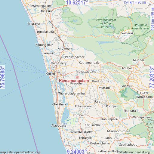
Rāmamangalam GPS coordinates[2]
9° 55' 59.988" North, 76° 30' 0" East
| Map corner | latitude | longitude |
|---|---|---|
| Upper-left | 10.62517°, | 75.79688° |
| Center: | 9.93333°, | 76.5° |
| Lower-right: | 9.24003°, | 77.20313° |
| Map W x H: | 154×154 km | = 95.7×95.7mi |
| max Lat: | 34.9274° ⇑96.6% North |
| Rāmamangalam: | 9.93333° |
| min Lat: | ⇓3.4% South 8.09008° |
| min Long | Rāmamangalam | max Long |
| 68.82655° | 76.5° | 96.81° |
| W 31.5%⇐ | ⇒68.5% E |
Elevation
Elevation of Rāmamangalam is 32 m = 105 ft, and this is 263.6 m = 865 ft below average elevation for this country.
| Max E: |
3681 m = 12077 ft | 84.4% |
| Avg. | 295.6 m = 970 ft | |
| Rāmamangalam | 32 m = 105 ft | |
Min E: |
1 m = 3 ft | 15.6% |
See also: India elevation on elevation.city.
Geographical zone
Rāmamangalam is located in North Torrid zone (between Equator and Tropic of Cancer). Distance of Equator is 1104.5 km =686.3 mi to South.| Distance of | km | miles | from Rāmamangalam |
|---|---|---|---|
| North Pole | 8902.6 | 5531.8 | to North |
| Arctic Circle | 6296.7 | 3912.6 | to North |
| Tropic Cancer | 1501.4 | 932.9 | to North |
| Equator | 1104.5 | 686.3 | to South |


Nearby cities:
15 places around Rāmamangalam: (largest is in red/bold)
• Aluva
25.3 km =15.7 mi,  320°
320°
• Alwaye
25 km =15.5 mi, 320°
• Aroor
22.5 km =14 mi,  251°
251°
• Arukutti
18 km =11.2 mi, 245°
• Kalamassery
23.8 km =14.8 mi,  306°
306°
• Kotamangalam
20.2 km =12.6 mi,  43°
43°
• Kumbalam
20.9 km =13 mi,  261°
261°
• Kutiatodu
23.5 km =14.6 mi,  230°
230°
• Muvattupuzha
9.6 km =6 mi,  57°
57°
• Mūvattupula
10.2 km =6.3 mi, 55°
• Palackattumala
25.4 km =15.8 mi,  146°
146°
• Perumbavoor
19.5 km =12.1 mi,  351°
351°
• Perumpāvūr
20.4 km =12.7 mi, 352°
• Piravam
7.4 km =4.6 mi,  180°
180°
• Vaikam
23.5 km =14.6 mi,  208°
208°
Sources, notices
• [Note1] Compared only with cities in India existing in our database
• [Src1] Map data: © OpenStreetMap contributors (CC-BY-SA)
• [Src2] Other city data from geonames.org with taken over terms of usage.
• [Src3] Geographical zone / Annual Mean Temperature by Robert A. Rohde @ Wikipedia
