Alappuzha geodata
Alappuzha (Kerala) is a seat of a second-order administrative division; located in India in Asia/Kolkata (GMT+5.5) time zone. With population of 176,783 people, there are 242 cities with bigger population in this country. Compared to other cities in India, 97.7% of cities are located further ↑North; 70.3% of cities are located further →East and 98.3% of cities have higher elevation than Alappuzha. Note1


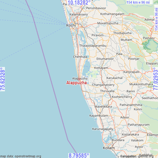
Alappuzha GPS coordinates[2]
9° 29' 24.144" North, 76° 19' 35.04" East
| Map corner | latitude | longitude |
|---|---|---|
| Upper-left | 10.18282°, | 75.62328° |
| Center: | 9.49004°, | 76.3264° |
| Lower-right: | 8.79585°, | 77.02953° |
| Map W x H: | 154.2×154.2 km | = 95.8×95.8mi |
| max Lat: | 34.9274° ⇑97.7% North |
| Alappuzha: | 9.49004° |
| min Lat: | ⇓2.3% South 8.09008° |
| min Long | Alappuzha | max Long |
| 68.82655° | 76.3264° | 96.81° |
| W 29.7%⇐ | ⇒70.3% E |
Elevation
Elevation of Alappuzha is 8 m = 26 ft, and this is 287.6 m = 944 ft below average elevation for this country.
| Max E: |
3681 m = 12077 ft | 98.3% |
| Avg. | 295.6 m = 970 ft | |
| Alappuzha | 8 m = 26 ft | |
Min E: |
1 m = 3 ft | 1.7% |
See also: Alappuzha elevation on elevation.city.
Geographical zone
Alappuzha is located in North Torrid zone (between Equator and Tropic of Cancer). Distance of Equator is 1055.2 km =655.7 mi to South.| Distance of | km | miles | from Alappuzha |
|---|---|---|---|
| North Pole | 8951.9 | 5562.5 | to North |
| Arctic Circle | 6346 | 3943.2 | to North |
| Tropic Cancer | 1550.7 | 963.6 | to North |
| Equator | 1055.2 | 655.7 | to South |


Nearby cities:
15 places around Alappuzha: (largest is in red/bold)
• Aroor
42.2 km =26.2 mi,  356°
356°
• Arukutti
42 km =26.1 mi,  3°
3°
• Changanācheri
23.6 km =14.7 mi,  103°
103°
• Chengannūr
37.1 km =23.1 mi,  121°
121°
• Cherthala
21.6 km =13.4 mi, 2°
• Kalavoor
8.9 km =5.5 mi, 0°
• Kottayam
23.9 km =14.9 mi,  63°
63°
• Kunnumma
17.6 km =10.9 mi,  147°
147°
• Kutiatodu
34.5 km =21.4 mi, 1°
• Kāyankulam
39.3 km =24.4 mi, 150°
• Māvelikara
36 km =22.4 mi,  135°
135°
• Shertallai
21.8 km =13.5 mi, 3°
• Tiruvalla
29.8 km =18.5 mi,  113°
113°
• Vaikam
29.8 km =18.5 mi,  14°
14°
• Vayalār
24.7 km =15.3 mi, 3°
Sources, notices
• [Note1] Compared only with cities in India existing in our database
• [Src1] Map data: © OpenStreetMap contributors (CC-BY-SA)
• [Src2] Other city data from geonames.org with taken over terms of usage.
• [Src3] Geographical zone / Annual Mean Temperature by Robert A. Rohde @ Wikipedia
