Vayalār geodata
Vayalār (Kerala) is a populated place; located in India in Asia/Kolkata (GMT+5.5) time zone. With population of 25,094 people, there are 1692 cities with bigger population in this country. Compared to other cities in India, 97.4% of cities are located further ↑North; 70% of cities are located further →East and 97.4% of cities have higher elevation than Vayalār. Note1


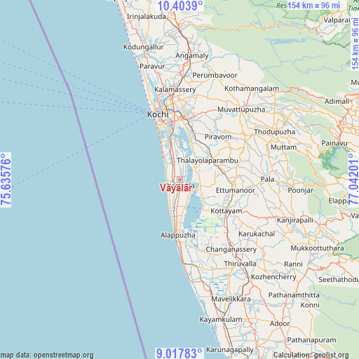
Vayalār GPS coordinates[2]
9° 42' 41.688" North, 76° 20' 19.968" East
| Map corner | latitude | longitude |
|---|---|---|
| Upper-left | 10.4039°, | 75.63576° |
| Center: | 9.71158°, | 76.33888° |
| Lower-right: | 9.01783°, | 77.04201° |
| Map W x H: | 154.1×154.1 km | = 95.8×95.8mi |
| max Lat: | 34.9274° ⇑97.4% North |
| Vayalār: | 9.71158° |
| min Lat: | ⇓2.6% South 8.09008° |
| min Long | Vayalār | max Long |
| 68.82655° | 76.33888° | 96.81° |
| W 30%⇐ | ⇒70% E |
Elevation
Elevation of Vayalār is 9 m = 30 ft, and this is 286.6 m = 940 ft below average elevation for this country.
| Max E: |
3681 m = 12077 ft | 97.4% |
| Avg. | 295.6 m = 970 ft | |
| Vayalār | 9 m = 30 ft | |
Min E: |
1 m = 3 ft | 2.6% |
See also: India elevation on elevation.city.
Geographical zone
Vayalār is located in North Torrid zone (between Equator and Tropic of Cancer). Distance of Equator is 1079.8 km =671 mi to South.| Distance of | km | miles | from Vayalār |
|---|---|---|---|
| North Pole | 8927.2 | 5547.1 | to North |
| Arctic Circle | 6321.3 | 3927.9 | to North |
| Tropic Cancer | 1526.1 | 948.3 | to North |
| Equator | 1079.8 | 671 | to South |


Nearby cities:
15 places around Vayalār: (largest is in red/bold)
• Alappuzha
24.7 km =15.3 mi,  183°
183°
• Aroor
17.9 km =11.1 mi,  348°
348°
• Arukutti
17.3 km =10.7 mi,  4°
4°
• Changanācheri
37 km =23 mi,  144°
144°
• Cherthala
3 km =1.9 mi,  186°
186°
• Cochin
26.8 km =16.7 mi,  341°
341°
• Kalavoor
15.7 km =9.8 mi, 184°
• Kottayam
24.3 km =15.1 mi,  124°
124°
• Kumbalam
21.9 km =13.6 mi, 352°
• Kutiatodu
9.9 km =6.2 mi,  356°
356°
• Palackattumala
32 km =19.9 mi,  83°
83°
• Piravam
24.7 km =15.3 mi,  45°
45°
• Rāmamangalam
30.3 km =18.8 mi,  35°
35°
• Shertallai
2.9 km =1.8 mi, 177°
• Vaikam
7.5 km =4.7 mi,  56°
56°
Sources, notices
• [Note1] Compared only with cities in India existing in our database
• [Src1] Map data: © OpenStreetMap contributors (CC-BY-SA)
• [Src2] Other city data from geonames.org with taken over terms of usage.
• [Src3] Geographical zone / Annual Mean Temperature by Robert A. Rohde @ Wikipedia
