Tiruvallur geodata
Tiruvallur (Tamil Nadu) is a populated place; located in India in Asia/Kolkata (GMT+5.5) time zone. With population of 48,095 people, there are 913 cities with bigger population in this country. Compared to other cities in India, 85.6% of cities are located further ↑North; 67.1% of cities are located further ←West and 80.5% of cities have higher elevation than Tiruvallur. Note1


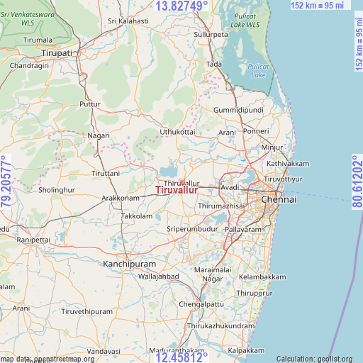
Tiruvallur GPS coordinates[2]
13° 8' 37.536" North, 79° 54' 32.004" East
| Map corner | latitude | longitude |
|---|---|---|
| Upper-left | 13.82749°, | 79.20577° |
| Center: | 13.14376°, | 79.90889° |
| Lower-right: | 12.45812°, | 80.61202° |
| Map W x H: | 152.3×152.3 km | = 94.6×94.6mi |
| max Lat: | 34.9274° ⇑85.6% North |
| Tiruvallur: | 13.14376° |
| min Lat: | ⇓14.4% South 8.09008° |
| min Long | Tiruvallur | max Long |
| 68.82655° | 79.90889° | 96.81° |
| W 67.1%⇐ | ⇒32.9% E |
Elevation
Elevation of Tiruvallur is 46 m = 151 ft, and this is 249.6 m = 819 ft below average elevation for this country.
| Max E: |
3681 m = 12077 ft | 80.5% |
| Avg. | 295.6 m = 970 ft | |
| Tiruvallur | 46 m = 151 ft | |
Min E: |
1 m = 3 ft | 19.5% |
See also: Tiruvallur elevation on elevation.city.
Geographical zone
Tiruvallur is located in North Torrid zone (between Equator and Tropic of Cancer). Distance of this Northern Tropic circle is 1144.5 km =711.2 mi to North.| Distance of | km | miles | from Tiruvallur |
|---|---|---|---|
| North Pole | 8545.6 | 5310 | to North |
| Arctic Circle | 5939.7 | 3690.8 | to North |
| Tropic Cancer | 1144.5 | 711.2 | to North |
| Equator | 1461.4 | 908.1 | to South |


Nearby cities:
15 places around Tiruvallur: (largest is in red/bold)
• Ambattūr
27.8 km =17.3 mi,  100°
100°
• Arakkonam
26.6 km =16.5 mi,  255°
255°
• Manappakkam
31.8 km =19.8 mi,  117°
117°
• Nandambakkam
25.2 km =15.7 mi,  136°
136°
• Nāravārikuppam
30.3 km =18.8 mi,  79°
79°
• Pallāvaram
32.6 km =20.3 mi,  126°
126°
• Poonamalle
24.7 km =15.3 mi, 115°
• Porur
29.6 km =18.4 mi,  113°
113°
• Puduvāyal
33 km =20.5 mi,  51°
51°
• Srīperumbūdūr
19.9 km =12.4 mi,  169°
169°
• Thiruthani
31.9 km =19.8 mi,  276°
276°
• Tinnanūr
13.2 km =8.2 mi, 104°
• Vandalūr
33.6 km =20.9 mi,  146°
146°
• Vellānūr
21.4 km =13.3 mi,  85°
85°
• Āvadi
22 km =13.7 mi, 98°
Sources, notices
• [Note1] Compared only with cities in India existing in our database
• [Src1] Map data: © OpenStreetMap contributors (CC-BY-SA)
• [Src2] Other city data from geonames.org with taken over terms of usage.
• [Src3] Geographical zone / Annual Mean Temperature by Robert A. Rohde @ Wikipedia
