Srīperumbūdūr geodata
Srīperumbūdūr (Tamil Nadu) is a populated place; located in India in Asia/Kolkata (GMT+5.5) time zone. With population of 17,253 people, there are 2264 cities with bigger population in this country. Compared to other cities in India, 86.6% of cities are located further ↑North; 67.4% of cities are located further ←West and 80.5% of cities have higher elevation than Srīperumbūdūr. Note1


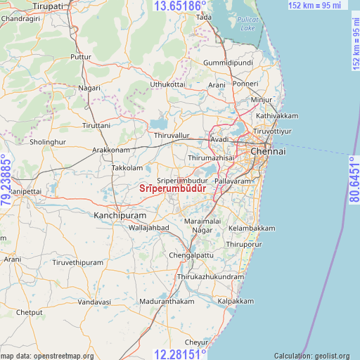
Srīperumbūdūr GPS coordinates[2]
12° 58' 3.468" North, 79° 56' 31.092" East
| Map corner | latitude | longitude |
|---|---|---|
| Upper-left | 13.65186°, | 79.23885° |
| Center: | 12.96763°, | 79.94197° |
| Lower-right: | 12.28151°, | 80.6451° |
| Map W x H: | 152.4×152.4 km | = 94.7×94.7mi |
| max Lat: | 34.9274° ⇑86.6% North |
| Srīperumbūdūr: | 12.96763° |
| min Lat: | ⇓13.4% South 8.09008° |
| min Long | Srīperumbūdū | max Long |
| 68.82655° | 79.94197° | 96.81° |
| W 67.4%⇐ | ⇒32.6% E |
Elevation
Elevation of Srīperumbūdūr is 46 m = 151 ft, and this is 249.6 m = 819 ft below average elevation for this country.
| Max E: |
3681 m = 12077 ft | 80.5% |
| Avg. | 295.6 m = 970 ft | |
| Srīperumbūdūr | 46 m = 151 ft | |
Min E: |
1 m = 3 ft | 19.5% |
See also: India elevation on elevation.city.
Geographical zone
Srīperumbūdūr is located in North Torrid zone (between Equator and Tropic of Cancer). Distance of this Northern Tropic circle is 1164.1 km =723.3 mi to North.| Distance of | km | miles | from Srīperumbūdūr |
|---|---|---|---|
| North Pole | 8565.2 | 5322.2 | to North |
| Arctic Circle | 5959.3 | 3702.9 | to North |
| Tropic Cancer | 1164.1 | 723.3 | to North |
| Equator | 1441.9 | 896 | to South |


Nearby cities:
15 places around Srīperumbūdūr: (largest is in red/bold)
• Gūduvāncheri
18.7 km =11.6 mi,  136°
136°
• Madambakkam
17.1 km =10.6 mi, 138°
• Manappakkam
25 km =15.5 mi,  78°
78°
• Nandambakkam
13.7 km =8.5 mi,  85°
85°
• Pallāvaram
22.6 km =14 mi, 89°
• Poonamalle
20.8 km =12.9 mi,  64°
64°
• Porur
24.6 km =15.3 mi,  72°
72°
• Singapperumālkovil
24.2 km =15 mi,  162°
162°
• Tambaram
20.6 km =12.8 mi,  103°
103°
• Tinnanūr
18.8 km =11.7 mi,  29°
29°
• Tiruvallur
19.9 km =12.4 mi,  349°
349°
• Vandalūr
17.2 km =10.7 mi,  119°
119°
• Vengavasal
25.8 km =16 mi,  107°
107°
• Wallajahbad
23.5 km =14.6 mi,  213°
213°
• Āvadi
24.5 km =15.2 mi,  48°
48°
Sources, notices
• [Note1] Compared only with cities in India existing in our database
• [Src1] Map data: © OpenStreetMap contributors (CC-BY-SA)
• [Src2] Other city data from geonames.org with taken over terms of usage.
• [Src3] Geographical zone / Annual Mean Temperature by Robert A. Rohde @ Wikipedia
