Arakkonam geodata
Arakkonam (Tamil Nadu) is a populated place; located in India in Asia/Kolkata (GMT+5.5) time zone. With population of 79,080 people, there are 553 cities with bigger population in this country. Compared to other cities in India, 86% of cities are located further ↑North; 65.4% of cities are located further ←West and 70.5% of cities have higher elevation than Arakkonam. Note1


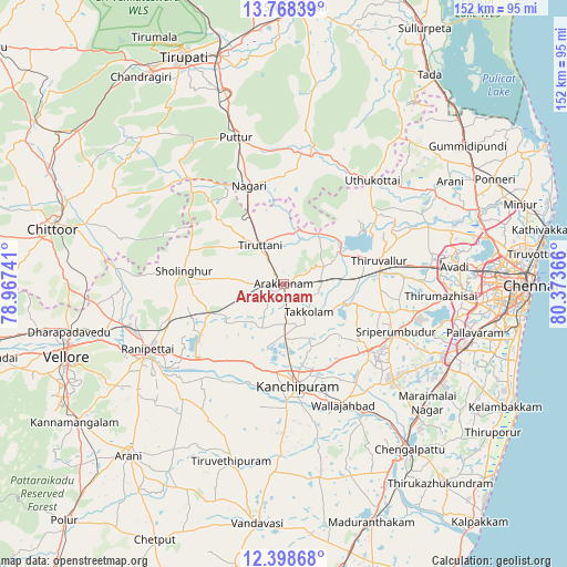
Arakkonam GPS coordinates[2]
13° 5' 4.164" North, 79° 40' 13.908" East
| Map corner | latitude | longitude |
|---|---|---|
| Upper-left | 13.76839°, | 78.96741° |
| Center: | 13.08449°, | 79.67053° |
| Lower-right: | 12.39868°, | 80.37366° |
| Map W x H: | 152.3×152.3 km | = 94.6×94.6mi |
| max Lat: | 34.9274° ⇑86% North |
| Arakkonam: | 13.08449° |
| min Lat: | ⇓14% South 8.09008° |
| min Long | Arakkonam | max Long |
| 68.82655° | 79.67053° | 96.81° |
| W 65.4%⇐ | ⇒34.6% E |
Elevation
Elevation of Arakkonam is 90 m = 295 ft, and this is 205.6 m = 675 ft below average elevation for this country.
| Max E: |
3681 m = 12077 ft | 70.5% |
| Avg. | 295.6 m = 970 ft | |
| Arakkonam | 90 m = 295 ft | |
Min E: |
1 m = 3 ft | 29.5% |
See also: Arakkonam elevation on elevation.city.
Geographical zone
Arakkonam is located in North Torrid zone (between Equator and Tropic of Cancer). Distance of this Northern Tropic circle is 1151.1 km =715.3 mi to North.| Distance of | km | miles | from Arakkonam |
|---|---|---|---|
| North Pole | 8552.2 | 5314.1 | to North |
| Arctic Circle | 5946.3 | 3694.9 | to North |
| Tropic Cancer | 1151.1 | 715.3 | to North |
| Equator | 1454.9 | 904 | to South |


Nearby cities:
15 places around Arakkonam: (largest is in red/bold)
• Arcot
43 km =26.7 mi,  242°
242°
• Dūsi
34.3 km =21.3 mi,  178°
178°
• Kalavai
44.2 km =27.5 mi,  217°
217°
• Kanchipuram
27.9 km =17.3 mi,  173°
173°
• Nagari
27.9 km =17.3 mi,  340°
340°
• Nārāyanavanam
39 km =24.2 mi,  346°
346°
• Pallipattu
37.3 km =23.2 mi,  319°
319°
• Puttūr
41.7 km =25.9 mi, 342°
• Sholinghur
27.4 km =17 mi,  277°
277°
• Srīperumbūdūr
32.1 km =19.9 mi,  113°
113°
• Thiruthani
11.7 km =7.3 mi,  330°
330°
• Tinnanūr
38.8 km =24.1 mi,  85°
85°
• Tiruvallur
26.6 km =16.5 mi,  75°
75°
• Walajapet
37.4 km =23.2 mi, 241°
• Wallajahbad
36.7 km =22.8 mi,  153°
153°
Sources, notices
• [Note1] Compared only with cities in India existing in our database
• [Src1] Map data: © OpenStreetMap contributors (CC-BY-SA)
• [Src2] Other city data from geonames.org with taken over terms of usage.
• [Src3] Geographical zone / Annual Mean Temperature by Robert A. Rohde @ Wikipedia
