Singapperumālkovil geodata
Singapperumālkovil (Tamil Nadu) is a populated place; located in India in Asia/Kolkata (GMT+5.5) time zone. With population of 8,301 people, there are 3100 cities with bigger population in this country. Compared to other cities in India, 87.6% of cities are located further ↑North; 67.9% of cities are located further ←West and 78.5% of cities have higher elevation than Singapperumālkovil. Note1


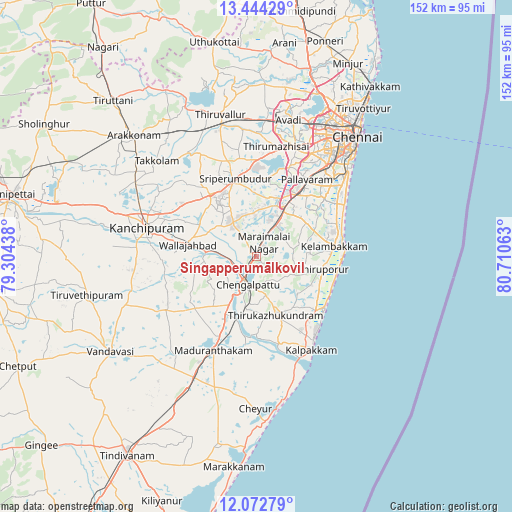
Singapperumālkovil GPS coordinates[2]
12° 45' 34.092" North, 80° 0' 27" East
| Map corner | latitude | longitude |
|---|---|---|
| Upper-left | 13.44429°, | 79.30438° |
| Center: | 12.75947°, | 80.0075° |
| Lower-right: | 12.07279°, | 80.71063° |
| Map W x H: | 152.5×152.5 km | = 94.8×94.8mi |
| max Lat: | 34.9274° ⇑87.6% North |
| Singapperumālkovil: | 12.75947° |
| min Lat: | ⇓12.4% South 8.09008° |
| min Long | Singapperumālk | max Long |
| 68.82655° | 80.0075° | 96.81° |
| W 67.9%⇐ | ⇒32.1% E |
Elevation
Elevation of Singapperumālkovil is 53 m = 174 ft, and this is 242.6 m = 796 ft below average elevation for this country.
| Max E: |
3681 m = 12077 ft | 78.5% |
| Avg. | 295.6 m = 970 ft | |
| Singapperumālkovil | 53 m = 174 ft | |
Min E: |
1 m = 3 ft | 21.5% |
See also: India elevation on elevation.city.
Geographical zone
Singapperumālkovil is located in North Torrid zone (between Equator and Tropic of Cancer). Distance of this Northern Tropic circle is 1187.2 km =737.7 mi to North.| Distance of | km | miles | from Singapperumālkovil |
|---|---|---|---|
| North Pole | 8588.3 | 5336.5 | to North |
| Arctic Circle | 5982.5 | 3717.4 | to North |
| Tropic Cancer | 1187.2 | 737.7 | to North |
| Equator | 1418.7 | 881.5 | to South |


Nearby cities:
15 places around Singapperumālkovil: (largest is in red/bold)
• Chingleput
8.2 km =5.1 mi,  204°
204°
• Gūduvāncheri
11.1 km =6.9 mi,  31°
31°
• Injambakkam
31.4 km =19.5 mi,  56°
56°
• Karumbākkam
11.1 km =6.9 mi,  125°
125°
• Madambakkam
11.2 km =7 mi,  22°
22°
• Madipakkam
30.6 km =19 mi,  42°
42°
• Madurāntakam
30.6 km =19 mi,  205°
205°
• Nandambakkam
25.2 km =15.7 mi, 15°
• Pallāvaram
27.9 km =17.3 mi, 33°
• Seven Pagodas
25.4 km =15.8 mi, 127°
• Srīperumbūdūr
24.2 km =15 mi,  342°
342°
• Tambaram
22.5 km =14 mi, 35°
• Vandalūr
16.8 km =10.4 mi, 28°
• Vengavasal
23.4 km =14.5 mi,  48°
48°
• Wallajahbad
20.2 km =12.6 mi,  279°
279°
Sources, notices
• [Note1] Compared only with cities in India existing in our database
• [Src1] Map data: © OpenStreetMap contributors (CC-BY-SA)
• [Src2] Other city data from geonames.org with taken over terms of usage.
• [Src3] Geographical zone / Annual Mean Temperature by Robert A. Rohde @ Wikipedia
