Wallajahbad geodata
Wallajahbad (Tamil Nadu) is a populated place; located in India in Asia/Kolkata (GMT+5.5) time zone. With population of 10,543 people, there are 2886 cities with bigger population in this country. Compared to other cities in India, 87.4% of cities are located further ↑North; 66.6% of cities are located further ←West and 76.3% of cities have higher elevation than Wallajahbad. Note1


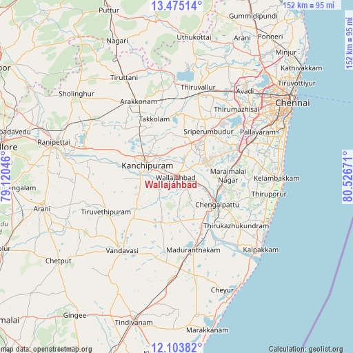
Wallajahbad GPS coordinates[2]
12° 47' 25.476" North, 79° 49' 24.888" East
| Map corner | latitude | longitude |
|---|---|---|
| Upper-left | 13.47514°, | 79.12046° |
| Center: | 12.79041°, | 79.82358° |
| Lower-right: | 12.10382°, | 80.52671° |
| Map W x H: | 152.5×152.5 km | = 94.8×94.8mi |
| max Lat: | 34.9274° ⇑87.4% North |
| Wallajahbad: | 12.79041° |
| min Lat: | ⇓12.6% South 8.09008° |
| min Long | Wallajahbad | max Long |
| 68.82655° | 79.82358° | 96.81° |
| W 66.6%⇐ | ⇒33.4% E |
Elevation
Elevation of Wallajahbad is 62 m = 203 ft, and this is 233.6 m = 766 ft below average elevation for this country.
| Max E: |
3681 m = 12077 ft | 76.3% |
| Avg. | 295.6 m = 970 ft | |
| Wallajahbad | 62 m = 203 ft | |
Min E: |
1 m = 3 ft | 23.7% |
See also: India elevation on elevation.city.
Geographical zone
Wallajahbad is located in North Torrid zone (between Equator and Tropic of Cancer). Distance of this Northern Tropic circle is 1183.8 km =735.6 mi to North.| Distance of | km | miles | from Wallajahbad |
|---|---|---|---|
| North Pole | 8584.9 | 5334.4 | to North |
| Arctic Circle | 5979 | 3715.2 | to North |
| Tropic Cancer | 1183.8 | 735.6 | to North |
| Equator | 1422.2 | 883.7 | to South |


Nearby cities:
15 places around Wallajahbad: (largest is in red/bold)
• Arakkonam
36.7 km =22.8 mi,  333°
333°
• Cheyyar
33.7 km =20.9 mi,  244°
244°
• Chingleput
19.9 km =12.4 mi,  123°
123°
• Dūsi
15.8 km =9.8 mi,  264°
264°
• Gūduvāncheri
26.4 km =16.4 mi,  76°
76°
• Kanchipuram
14.3 km =8.9 mi,  290°
290°
• Karumbākkam
30.6 km =19 mi,  108°
108°
• Madambakkam
25.2 km =15.7 mi,  74°
74°
• Madurāntakam
31.7 km =19.7 mi,  167°
167°
• Nandambakkam
33.7 km =20.9 mi,  51°
51°
• Singapperumālkovil
20.2 km =12.6 mi,  99°
99°
• Srīperumbūdūr
23.5 km =14.6 mi,  33°
33°
• Tambaram
36.1 km =22.4 mi, 65°
• Uttiramerūr
20.8 km =12.9 mi,  200°
200°
• Vandalūr
30.1 km =18.7 mi, 67°
Sources, notices
• [Note1] Compared only with cities in India existing in our database
• [Src1] Map data: © OpenStreetMap contributors (CC-BY-SA)
• [Src2] Other city data from geonames.org with taken over terms of usage.
• [Src3] Geographical zone / Annual Mean Temperature by Robert A. Rohde @ Wikipedia
