Sāvantvādi geodata
Sāvantvādi (Maharashtra) is a populated place; located in India in Asia/Kolkata (GMT+5.5) time zone. With population of 23,384 people, there are 1811 cities with bigger population in this country. Compared to other cities in India, 78.2% of cities are located further ↑North; 91.1% of cities are located further →East and 66.8% of cities have higher elevation than Sāvantvādi. Note1


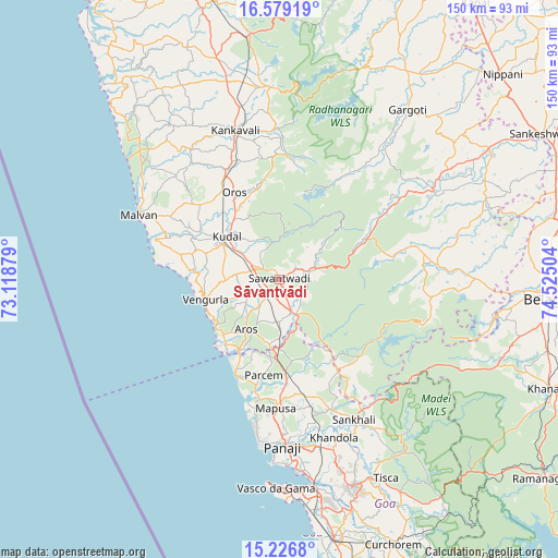
Sāvantvādi GPS coordinates[2]
15° 54' 14.868" North, 73° 49' 18.876" East
| Map corner | latitude | longitude |
|---|---|---|
| Upper-left | 16.57919°, | 73.11879° |
| Center: | 15.90413°, | 73.82191° |
| Lower-right: | 15.2268°, | 74.52504° |
| Map W x H: | 150.4×150.4 km | = 93.5×93.5mi |
| max Lat: | 34.9274° ⇑78.2% North |
| Sāvantvādi: | 15.90413° |
| min Lat: | ⇓21.8% South 8.09008° |
| min Long | Sāvantvādi | max Long |
| 68.82655° | 73.82191° | 96.81° |
| W 8.9%⇐ | ⇒91.1% E |
Elevation
Elevation of Sāvantvādi is 107 m = 351 ft, and this is 188.6 m = 619 ft below average elevation for this country.
| Max E: |
3681 m = 12077 ft | 66.8% |
| Avg. | 295.6 m = 970 ft | |
| Sāvantvādi | 107 m = 351 ft | |
Min E: |
1 m = 3 ft | 33.2% |
See also: India elevation on elevation.city.
Geographical zone
Sāvantvādi is located in North Torrid zone (between Equator and Tropic of Cancer). Distance of this Northern Tropic circle is 837.5 km =520.4 mi to North.| Distance of | km | miles | from Sāvantvādi |
|---|---|---|---|
| North Pole | 8238.7 | 5119.3 | to North |
| Arctic Circle | 5632.8 | 3500.1 | to North |
| Tropic Cancer | 837.5 | 520.4 | to North |
| Equator | 1768.4 | 1098.8 | to South |


Nearby cities:
15 places around Sāvantvādi: (largest is in red/bold)
• Aldona
35 km =21.7 mi,  170°
170°
• Arambol
27.2 km =16.9 mi,  207°
207°
• Baga
38.4 km =23.9 mi,  190°
190°
• Chapora
34.6 km =21.5 mi, 194°
• Colovale
29.9 km =18.6 mi,  179°
179°
• Dicholi
37 km =23 mi,  159°
159°
• Guirim
36.6 km =22.7 mi, 182°
• Kudāl
18.6 km =11.6 mi,  309°
309°
• Morjim
31.6 km =19.6 mi,  196°
196°
• Māpuca
34.8 km =21.6 mi, 182°
• Pernem
20.3 km =12.6 mi, 188°
• Saligao
39.1 km =24.3 mi, 184°
• Solim
32.7 km =20.3 mi, 190°
• Vagator
35.1 km =21.8 mi, 193°
• Vengurla
20.9 km =13 mi,  256°
256°
Sources, notices
• [Note1] Compared only with cities in India existing in our database
• [Src1] Map data: © OpenStreetMap contributors (CC-BY-SA)
• [Src2] Other city data from geonames.org with taken over terms of usage.
• [Src3] Geographical zone / Annual Mean Temperature by Robert A. Rohde @ Wikipedia
