Sanguem geodata
Sanguem (Goa) is a populated place; located in India in Asia/Kolkata (GMT+5.5) time zone. With population of 6,119 people, there are 3278 cities with bigger population in this country. Compared to other cities in India, 81.2% of cities are located further ↑North; 88.6% of cities are located further →East and 86.4% of cities have higher elevation than Sanguem. Note1


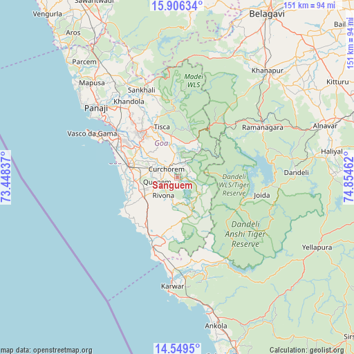
Sanguem GPS coordinates[2]
15° 13' 44.436" North, 74° 9' 5.364" East
| Map corner | latitude | longitude |
|---|---|---|
| Upper-left | 15.90634°, | 73.44837° |
| Center: | 15.22901°, | 74.15149° |
| Lower-right: | 14.5495°, | 74.85462° |
| Map W x H: | 150.9×150.9 km | = 93.8×93.8mi |
| max Lat: | 34.9274° ⇑81.2% North |
| Sanguem: | 15.22901° |
| min Lat: | ⇓18.8% South 8.09008° |
| min Long | Sanguem | max Long |
| 68.82655° | 74.15149° | 96.81° |
| W 11.4%⇐ | ⇒88.6% E |
Elevation
Elevation of Sanguem is 26 m = 85 ft, and this is 269.6 m = 885 ft below average elevation for this country.
| Max E: |
3681 m = 12077 ft | 86.4% |
| Avg. | 295.6 m = 970 ft | |
| Sanguem | 26 m = 85 ft | |
Min E: |
1 m = 3 ft | 13.6% |
See also: India elevation on elevation.city.
Geographical zone
Sanguem is located in North Torrid zone (between Equator and Tropic of Cancer). Distance of this Northern Tropic circle is 912.6 km =567.1 mi to North.| Distance of | km | miles | from Sanguem |
|---|---|---|---|
| North Pole | 8313.8 | 5166 | to North |
| Arctic Circle | 5707.9 | 3546.7 | to North |
| Tropic Cancer | 912.6 | 567.1 | to North |
| Equator | 1693.3 | 1052.2 | to South |


Nearby cities:
15 places around Sanguem: (largest is in red/bold)
• Benaulim
24.3 km =15.1 mi,  279°
279°
• Cavelossim
23.3 km =14.5 mi,  254°
254°
• Chinchinim
18.9 km =11.7 mi,  265°
265°
• Colva
25.2 km =15.7 mi, 282°
• Cuncolim
17.9 km =11.1 mi, 251°
• Curchorem
6 km =3.7 mi,  309°
309°
• Davorlim
17.7 km =11 mi,  285°
285°
• Kānkon
25.1 km =15.6 mi,  206°
206°
• Madgaon
21.4 km =13.3 mi, 283°
• Ponda
24.3 km =15.1 mi,  322°
322°
• Quepem
8.2 km =5.1 mi,  257°
257°
• Queula
25.2 km =15.7 mi, 315°
• Raia
21.1 km =13.1 mi, 293°
• Sanvordem
5.1 km =3.2 mi, 317°
• Varca
22.4 km =13.9 mi, 270°
Sources, notices
• [Note1] Compared only with cities in India existing in our database
• [Src1] Map data: © OpenStreetMap contributors (CC-BY-SA)
• [Src2] Other city data from geonames.org with taken over terms of usage.
• [Src3] Geographical zone / Annual Mean Temperature by Robert A. Rohde @ Wikipedia
