Benaulim geodata
Benaulim (Goa) is a populated place; located in India in Asia/Kolkata (GMT+5.5) time zone. With population of 10,224 people, there are 2920 cities with bigger population in this country. Compared to other cities in India, 81% of cities are located further ↑North; 90.1% of cities are located further →East and 89.3% of cities have higher elevation than Benaulim. Note1


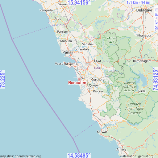
Benaulim GPS coordinates[2]
15° 15' 51.66" North, 73° 55' 41.232" East
| Map corner | latitude | longitude |
|---|---|---|
| Upper-left | 15.94156°, | 73.225° |
| Center: | 15.26435°, | 73.92812° |
| Lower-right: | 14.58495°, | 74.63125° |
| Map W x H: | 150.8×150.8 km | = 93.7×93.7mi |
| max Lat: | 34.9274° ⇑81% North |
| Benaulim: | 15.26435° |
| min Lat: | ⇓19% South 8.09008° |
| min Long | Benaulim | max Long |
| 68.82655° | 73.92812° | 96.81° |
| W 9.9%⇐ | ⇒90.1% E |
Elevation
Elevation of Benaulim is 19 m = 62 ft, and this is 276.6 m = 907 ft below average elevation for this country.
| Max E: |
3681 m = 12077 ft | 89.3% |
| Avg. | 295.6 m = 970 ft | |
| Benaulim | 19 m = 62 ft | |
Min E: |
1 m = 3 ft | 10.7% |
See also: India elevation on elevation.city.
Geographical zone
Benaulim is located in North Torrid zone (between Equator and Tropic of Cancer). Distance of this Northern Tropic circle is 908.7 km =564.6 mi to North.| Distance of | km | miles | from Benaulim |
|---|---|---|---|
| North Pole | 8309.8 | 5163.5 | to North |
| Arctic Circle | 5703.9 | 3544.2 | to North |
| Tropic Cancer | 908.7 | 564.6 | to North |
| Equator | 1697.2 | 1054.6 | to South |


Nearby cities:
15 places around Benaulim: (largest is in red/bold)
• Bandora
17 km =10.6 mi,  19°
19°
• Cavelossim
10.3 km =6.4 mi,  171°
171°
• Chicalim
17.5 km =10.9 mi,  328°
328°
• Chinchinim
7.5 km =4.7 mi,  137°
137°
• Colva
1.8 km =1.1 mi,  341°
341°
• Cortalim
15.5 km =9.6 mi,  352°
352°
• Cuncolim
12 km =7.5 mi, 143°
• Davorlim
7 km =4.3 mi,  82°
82°
• Madgaon
3.4 km =2.1 mi,  69°
69°
• Ponda
18.1 km =11.2 mi,  31°
31°
• Quepem
17 km =10.6 mi,  109°
109°
• Queula
15.3 km =9.5 mi, 23°
• Raia
6.4 km =4 mi,  45°
45°
• Sancoale
12.9 km =8 mi, 348°
• Varca
3.9 km =2.4 mi,  155°
155°
Sources, notices
• [Note1] Compared only with cities in India existing in our database
• [Src1] Map data: © OpenStreetMap contributors (CC-BY-SA)
• [Src2] Other city data from geonames.org with taken over terms of usage.
• [Src3] Geographical zone / Annual Mean Temperature by Robert A. Rohde @ Wikipedia
