Perumpāvūr geodata
Perumpāvūr (Kerala) is a populated place; located in India in Asia/Kolkata (GMT+5.5) time zone. With population of 27,105 people, there are 1581 cities with bigger population in this country. Compared to other cities in India, 96% of cities are located further ↑North; 68.7% of cities are located further →East and 84.4% of cities have higher elevation than Perumpāvūr. Note1


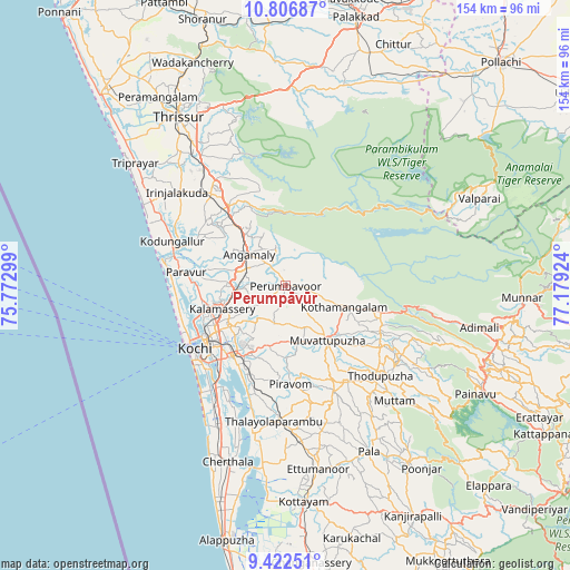
Perumpāvūr GPS coordinates[2]
10° 6' 55.584" North, 76° 28' 33.996" East
| Map corner | latitude | longitude |
|---|---|---|
| Upper-left | 10.80687°, | 75.77299° |
| Center: | 10.11544°, | 76.47611° |
| Lower-right: | 9.42251°, | 77.17924° |
| Map W x H: | 153.9×153.9 km | = 95.6×95.6mi |
| max Lat: | 34.9274° ⇑96% North |
| Perumpāvūr: | 10.11544° |
| min Lat: | ⇓4% South 8.09008° |
| min Long | Perumpāvūr | max Long |
| 68.82655° | 76.47611° | 96.81° |
| W 31.3%⇐ | ⇒68.7% E |
Elevation
Elevation of Perumpāvūr is 32 m = 105 ft, and this is 263.6 m = 865 ft below average elevation for this country.
| Max E: |
3681 m = 12077 ft | 84.4% |
| Avg. | 295.6 m = 970 ft | |
| Perumpāvūr | 32 m = 105 ft | |
Min E: |
1 m = 3 ft | 15.6% |
See also: India elevation on elevation.city.
Geographical zone
Perumpāvūr is located in North Torrid zone (between Equator and Tropic of Cancer). Distance of Equator is 1124.7 km =698.9 mi to South.| Distance of | km | miles | from Perumpāvūr |
|---|---|---|---|
| North Pole | 8882.3 | 5519.2 | to North |
| Arctic Circle | 6276.4 | 3900 | to North |
| Tropic Cancer | 1481.2 | 920.4 | to North |
| Equator | 1124.7 | 698.9 | to South |


Nearby cities:
15 places around Perumpāvūr: (largest is in red/bold)
• Aluva
13.7 km =8.5 mi,  266°
266°
• Alwaye
13.3 km =8.3 mi, 265°
• Angamāli
12.8 km =8 mi,  310°
310°
• Cochin
30.7 km =19.1 mi,  230°
230°
• Elūr
21.8 km =13.5 mi,  255°
255°
• Kalamassery
17.5 km =10.9 mi,  249°
249°
• Kizhake Chālakudi
25.6 km =15.9 mi,  323°
323°
• Kotamangalam
17.6 km =10.9 mi,  108°
108°
• Kumbalam
29.4 km =18.3 mi,  217°
217°
• Kuttampuzha
28.6 km =17.8 mi,  82°
82°
• Muvattupuzha
18.5 km =11.5 mi,  144°
144°
• Mūvattupula
18.3 km =11.4 mi, 142°
• Perumbavoor
1 km =0.6 mi,  195°
195°
• Piravam
27.8 km =17.3 mi,  174°
174°
• Rāmamangalam
20.4 km =12.7 mi, 172°
Sources, notices
• [Note1] Compared only with cities in India existing in our database
• [Src1] Map data: © OpenStreetMap contributors (CC-BY-SA)
• [Src2] Other city data from geonames.org with taken over terms of usage.
• [Src3] Geographical zone / Annual Mean Temperature by Robert A. Rohde @ Wikipedia
