Kotamangalam geodata
Kotamangalam (Kerala) is a populated place; located in India in Asia/Kolkata (GMT+5.5) time zone. With population of 37,543 people, there are 1175 cities with bigger population in this country. Compared to other cities in India, 96.3% of cities are located further ↑North; 66.9% of cities are located further →East and 86.4% of cities have higher elevation than Kotamangalam. Note1


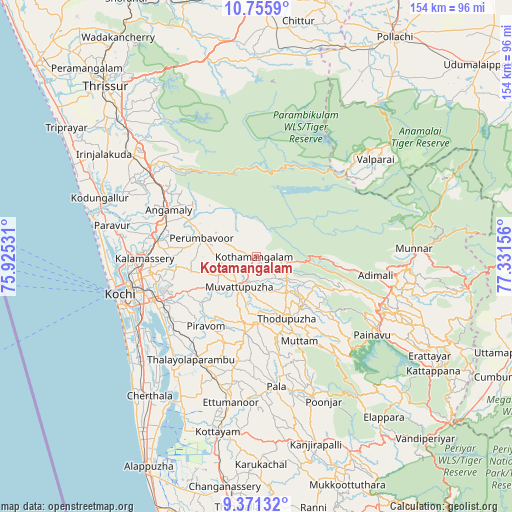
Kotamangalam GPS coordinates[2]
10° 3' 51.66" North, 76° 37' 42.348" East
| Map corner | latitude | longitude |
|---|---|---|
| Upper-left | 10.7559°, | 75.92531° |
| Center: | 10.06435°, | 76.62843° |
| Lower-right: | 9.37132°, | 77.33156° |
| Map W x H: | 154×154 km | = 95.7×95.7mi |
| max Lat: | 34.9274° ⇑96.3% North |
| Kotamangalam: | 10.06435° |
| min Lat: | ⇓3.7% South 8.09008° |
| min Long | Kotamangalam | max Long |
| 68.82655° | 76.62843° | 96.81° |
| W 33.1%⇐ | ⇒66.9% E |
Elevation
Elevation of Kotamangalam is 26 m = 85 ft, and this is 269.6 m = 885 ft below average elevation for this country.
| Max E: |
3681 m = 12077 ft | 86.4% |
| Avg. | 295.6 m = 970 ft | |
| Kotamangalam | 26 m = 85 ft | |
Min E: |
1 m = 3 ft | 13.6% |
See also: India elevation on elevation.city.
Geographical zone
Kotamangalam is located in North Torrid zone (between Equator and Tropic of Cancer). Distance of Equator is 1119.1 km =695.4 mi to South.| Distance of | km | miles | from Kotamangalam |
|---|---|---|---|
| North Pole | 8888 | 5522.7 | to North |
| Arctic Circle | 6282.1 | 3903.5 | to North |
| Tropic Cancer | 1486.9 | 923.9 | to North |
| Equator | 1119.1 | 695.4 | to South |


Nearby cities:
15 places around Kotamangalam: (largest is in red/bold)
• Aluva
30.7 km =19.1 mi,  279°
279°
• Alwaye
30.3 km =18.8 mi, 278°
• Angamāli
29.8 km =18.5 mi,  298°
298°
• Arukutti
37.6 km =23.4 mi,  234°
234°
• Elūr
37.8 km =23.5 mi,  270°
270°
• Kalamassery
33.1 km =20.6 mi, 269°
• Kumbalam
38.9 km =24.2 mi,  243°
243°
• Kuttampuzha
15.1 km =9.4 mi,  50°
50°
• Muvattupuzha
11.1 km =6.9 mi,  212°
212°
• Mūvattupula
10.5 km =6.5 mi, 212°
• Palackattumala
35.7 km =22.2 mi,  179°
179°
• Perumbavoor
17.6 km =10.9 mi,  285°
285°
• Perumpāvūr
17.6 km =10.9 mi, 288°
• Piravam
26.1 km =16.2 mi, 212°
• Rāmamangalam
20.2 km =12.6 mi,  223°
223°
Sources, notices
• [Note1] Compared only with cities in India existing in our database
• [Src1] Map data: © OpenStreetMap contributors (CC-BY-SA)
• [Src2] Other city data from geonames.org with taken over terms of usage.
• [Src3] Geographical zone / Annual Mean Temperature by Robert A. Rohde @ Wikipedia
