Rādhākund geodata
Rādhākund (Uttar Pradesh) is a populated place; located in India in Asia/Kolkata (GMT+5.5) time zone. With population of 6,420 people, there are 3259 cities with bigger population in this country. Compared to other cities in India, 82% of cities are located further ↓South; 57.4% of cities are located further →East and 52% of cities have higher elevation than Rādhākund. Note1


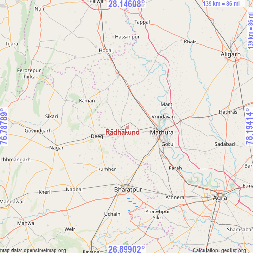
Rādhākund GPS coordinates[2]
27° 31' 27.552" North, 77° 29' 27.636" East
| Map corner | latitude | longitude |
|---|---|---|
| Upper-left | 28.14608°, | 76.78789° |
| Center: | 27.52432°, | 77.49101° |
| Lower-right: | 26.89902°, | 78.19414° |
| Map W x H: | 138.7×138.7 km | = 86.2×86.2mi |
| max Lat: | 34.9274° ⇑18% North |
| Rādhākund: | 27.52432° |
| min Lat: | ⇓82% South 8.09008° |
| min Long | Rādhākund | max Long |
| 68.82655° | 77.49101° | 96.81° |
| W 42.6%⇐ | ⇒57.4% E |
Elevation
Elevation of Rādhākund is 190 m = 623 ft, and this is 105.6 m = 346 ft below average elevation for this country.
| Max E: |
3681 m = 12077 ft | 52% |
| Avg. | 295.6 m = 970 ft | |
| Rādhākund | 190 m = 623 ft | |
Min E: |
1 m = 3 ft | 48% |
See also: India elevation on elevation.city.
Geographical zone
Rādhākund is located in North temperate zone (between Tropic of Cancer and the Arctic Circle). Distance of this Northern Tropic circle is 454.5 km =282.4 mi to South.| Distance of | km | miles | from Rādhākund |
|---|---|---|---|
| North Pole | 6946.6 | 4316.4 | to North |
| Arctic Circle | 4340.8 | 2697.2 | to North |
| Tropic Cancer | 454.5 | 282.4 | to South |
| Equator | 3060.4 | 1901.6 | to South |


Nearby cities:
15 places around Rādhākund: (largest is in red/bold)
• Barsāna
17.8 km =11.1 mi,  320°
320°
• Bharatpur
34.1 km =21.2 mi,  180°
180°
• Chhāta
22.2 km =13.8 mi,  4°
4°
• Dīg
17.3 km =10.7 mi,  250°
250°
• Farah
35 km =21.7 mi,  130°
130°
• Gokul
24.5 km =15.2 mi,  112°
112°
• Govardhan
4.2 km =2.6 mi,  222°
222°
• Kosi
30.5 km =19 mi,  349°
349°
• Kāman
26.4 km =16.4 mi,  304°
304°
• Kūmher
26 km =16.2 mi,  207°
207°
• Mahāban
26.9 km =16.7 mi, 112°
• Mathura
18 km =11.2 mi,  97°
97°
• Nandgaon
23.2 km =14.4 mi,  333°
333°
• Rāya
29.7 km =18.5 mi,  83°
83°
• Vrindāvan
21.2 km =13.2 mi,  72°
72°
Sources, notices
• [Note1] Compared only with cities in India existing in our database
• [Src1] Map data: © OpenStreetMap contributors (CC-BY-SA)
• [Src2] Other city data from geonames.org with taken over terms of usage.
• [Src3] Geographical zone / Annual Mean Temperature by Robert A. Rohde @ Wikipedia
