Bharatpur geodata
Bharatpur (Rajasthan) is a populated place; located in India in Asia/Kolkata (GMT+5.5) time zone. With population of 229,384 people, there are 184 cities with bigger population in this country. Compared to other cities in India, 80.2% of cities are located further ↓South; 57.4% of cities are located further →East and 54% of cities have higher elevation than Bharatpur. Note1


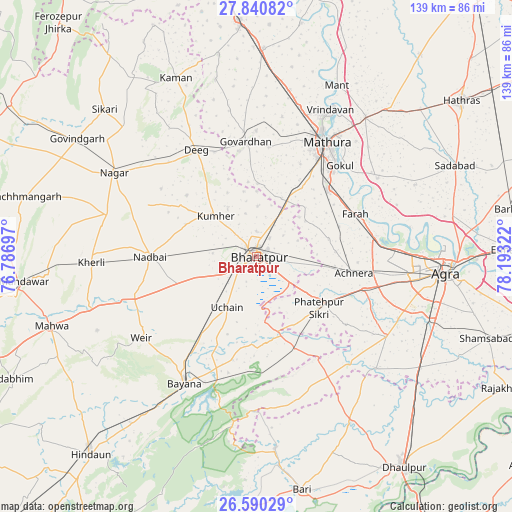
Bharatpur GPS coordinates[2]
27° 13' 2.316" North, 77° 29' 24.324" East
| Map corner | latitude | longitude |
|---|---|---|
| Upper-left | 27.84082°, | 76.78697° |
| Center: | 27.21731°, | 77.49009° |
| Lower-right: | 26.59029°, | 78.19322° |
| Map W x H: | 139×139 km | = 86.4×86.4mi |
| max Lat: | 34.9274° ⇑19.8% North |
| Bharatpur: | 27.21731° |
| min Lat: | ⇓80.2% South 8.09008° |
| min Long | Bharatpur | max Long |
| 68.82655° | 77.49009° | 96.81° |
| W 42.6%⇐ | ⇒57.4% E |
Elevation
Elevation of Bharatpur is 180 m = 591 ft, and this is 115.6 m = 379 ft below average elevation for this country.
| Max E: |
3681 m = 12077 ft | 54% |
| Avg. | 295.6 m = 970 ft | |
| Bharatpur | 180 m = 591 ft | |
Min E: |
1 m = 3 ft | 46% |
See also: Bharatpur elevation on elevation.city.
Geographical zone
Bharatpur is located in North temperate zone (between Tropic of Cancer and the Arctic Circle). Distance of this Northern Tropic circle is 420.4 km =261.2 mi to South.| Distance of | km | miles | from Bharatpur |
|---|---|---|---|
| North Pole | 6980.8 | 4337.7 | to North |
| Arctic Circle | 4374.9 | 2718.4 | to North |
| Tropic Cancer | 420.4 | 261.2 | to South |
| Equator | 3026.3 | 1880.5 | to South |


Nearby cities:
15 places around Bharatpur: (largest is in red/bold)
• Achhnera
26.7 km =16.6 mi,  99°
99°
• Baldev
39 km =24.2 mi,  57°
57°
• Bayāna
39.7 km =24.7 mi,  209°
209°
• Dīg
32.6 km =20.3 mi,  330°
330°
• Farah
29.2 km =18.1 mi,  66°
66°
• Fatehpur Sīkri
21.7 km =13.5 mi,  129°
129°
• Gokul
33.6 km =20.9 mi,  42°
42°
• Govardhan
31.2 km =19.4 mi,  355°
355°
• Kiraoli
30.5 km =19 mi,  106°
106°
• Kūmher
16.2 km =10.1 mi,  313°
313°
• Mahāban
34.6 km =21.5 mi,  46°
46°
• Mathura
36.5 km =22.7 mi,  29°
29°
• Nādbai
29.1 km =18.1 mi,  271°
271°
• Rādhākund
34.1 km =21.2 mi,  0°
0°
• Wer
38.1 km =23.7 mi,  234°
234°
Sources, notices
• [Note1] Compared only with cities in India existing in our database
• [Src1] Map data: © OpenStreetMap contributors (CC-BY-SA)
• [Src2] Other city data from geonames.org with taken over terms of usage.
• [Src3] Geographical zone / Annual Mean Temperature by Robert A. Rohde @ Wikipedia
