Gokul geodata
Gokul (Uttar Pradesh) is a populated place; located in India in Asia/Kolkata (GMT+5.5) time zone. With population of 4,351 people, there are 3365 cities with bigger population in this country. Compared to other cities in India, 81.5% of cities are located further ↓South; 54.8% of cities are located further →East and 55.1% of cities have higher elevation than Gokul. Note1


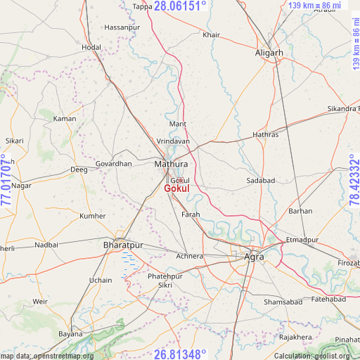
Gokul GPS coordinates[2]
27° 26' 21.336" North, 77° 43' 12.684" East
| Map corner | latitude | longitude |
|---|---|---|
| Upper-left | 28.06151°, | 77.01707° |
| Center: | 27.43926°, | 77.72019° |
| Lower-right: | 26.81348°, | 78.42332° |
| Map W x H: | 138.8×138.8 km | = 86.2×86.2mi |
| max Lat: | 34.9274° ⇑18.5% North |
| Gokul: | 27.43926° |
| min Lat: | ⇓81.5% South 8.09008° |
| min Long | Gokul | max Long |
| 68.82655° | 77.72019° | 96.81° |
| W 45.2%⇐ | ⇒54.8% E |
Elevation
Elevation of Gokul is 174 m = 571 ft, and this is 121.6 m = 399 ft below average elevation for this country.
| Max E: |
3681 m = 12077 ft | 55.1% |
| Avg. | 295.6 m = 970 ft | |
| Gokul | 174 m = 571 ft | |
Min E: |
1 m = 3 ft | 44.9% |
See also: India elevation on elevation.city.
Geographical zone
Gokul is located in North temperate zone (between Tropic of Cancer and the Arctic Circle). Distance of this Northern Tropic circle is 445 km =276.5 mi to South.| Distance of | km | miles | from Gokul |
|---|---|---|---|
| North Pole | 6956.1 | 4322.3 | to North |
| Arctic Circle | 4350.2 | 2703.1 | to North |
| Tropic Cancer | 445 | 276.5 | to South |
| Equator | 3051 | 1895.8 | to South |


Nearby cities:
15 places around Gokul: (largest is in red/bold)
• Achhnera
29.2 km =18.1 mi,  172°
172°
• Baldev
10.7 km =6.6 mi,  109°
109°
• Beswān
27.1 km =16.8 mi,  35°
35°
• Bharatpur
33.6 km =20.9 mi,  222°
222°
• Farah
13.8 km =8.6 mi,  162°
162°
• Govardhan
26.2 km =16.3 mi,  284°
284°
• Hāthras
37 km =23 mi,  62°
62°
• Kiraoli
34.1 km =21.2 mi, 169°
• Mahāban
2.4 km =1.5 mi, 107°
• Mathura
8.6 km =5.3 mi,  326°
326°
• Mursān
26.7 km =16.6 mi,  54°
54°
• Rādhākund
24.5 km =15.2 mi,  292°
292°
• Rāya
14.7 km =9.1 mi,  27°
27°
• Sadābād
31.3 km =19.4 mi,  90°
90°
• Vrindāvan
15.9 km =9.9 mi,  351°
351°
Sources, notices
• [Note1] Compared only with cities in India existing in our database
• [Src1] Map data: © OpenStreetMap contributors (CC-BY-SA)
• [Src2] Other city data from geonames.org with taken over terms of usage.
• [Src3] Geographical zone / Annual Mean Temperature by Robert A. Rohde @ Wikipedia
