Kosi geodata
Kosi (Uttar Pradesh) is a populated place; located in India in Asia/Kolkata (GMT+5.5) time zone. With population of 52,492 people, there are 854 cities with bigger population in this country. Compared to other cities in India, 83.4% of cities are located further ↓South; 57.9% of cities are located further →East and 51.3% of cities have higher elevation than Kosi. Note1


Kosi GPS coordinates[2]
27° 47' 40.164" North, 77° 26' 12.48" East
| Map corner | latitude | longitude |
|---|---|---|
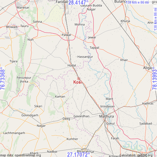
| Upper-left | 28.4147°, | 76.73368° |
| Center: | 27.79449°, | 77.4368° |
| Lower-right: | 27.17072°, | 78.13993° |
| Map W x H: | 138.3×138.3 km | = 85.9×85.9mi |
| max Lat: | 34.9274° ⇑16.6% North |
| Kosi: | 27.79449° |
| min Lat: | ⇓83.4% South 8.09008° |
| min Long | Kosi | max Long |
| 68.82655° | 77.4368° | 96.81° |
| W 42.1%⇐ | ⇒57.9% E |
Elevation
Elevation of Kosi is 195 m = 640 ft, and this is 100.6 m = 330 ft below average elevation for this country.
| Max E: |
3681 m = 12077 ft | 51.3% |
| Avg. | 295.6 m = 970 ft | |
| Kosi | 195 m = 640 ft | |
Min E: |
1 m = 3 ft | 48.7% |
See also: Kosi elevation on elevation.city.
Geographical zone
Kosi is located in North temperate zone (between Tropic of Cancer and the Arctic Circle). Distance of this Northern Tropic circle is 484.5 km =301.1 mi to South.| Distance of | km | miles | from Kosi |
|---|---|---|---|
| North Pole | 6916.6 | 4297.8 | to North |
| Arctic Circle | 4310.7 | 2678.5 | to North |
| Tropic Cancer | 484.5 | 301.1 | to South |
| Equator | 3090.5 | 1920.3 | to South |


Nearby cities:
15 places around Kosi: (largest is in red/bold)
• Barsāna
17.3 km =10.7 mi,  200°
200°
• Bājna
26.4 km =16.4 mi,  64°
64°
• Chhāta
10.5 km =6.5 mi,  138°
138°
• Dīg
37.5 km =23.3 mi, 196°
• Govardhan
33.2 km =20.6 mi,  175°
175°
• Hasanpur
20.3 km =12.6 mi,  16°
16°
• Hodal
12.8 km =8 mi,  327°
327°
• Jewar
38.3 km =23.8 mi, 18°
• Kāman
22.4 km =13.9 mi,  227°
227°
• Mathura
39.8 km =24.7 mi, 144°
• Nandgaon
10.5 km =6.5 mi,  208°
208°
• Palwal
40.4 km =25.1 mi,  344°
344°
• Pūnāhāna
24.1 km =15 mi,  288°
288°
• Rādhākund
30.5 km =19 mi,  169°
169°
• Vrindāvan
34.9 km =21.7 mi,  132°
132°
Sources, notices
• [Note1] Compared only with cities in India existing in our database
• [Src1] Map data: © OpenStreetMap contributors (CC-BY-SA)
• [Src2] Other city data from geonames.org with taken over terms of usage.
• [Src3] Geographical zone / Annual Mean Temperature by Robert A. Rohde @ Wikipedia
