Puttūr geodata
Puttūr (Andhra Pradesh) is a populated place; located in India in Asia/Kolkata (GMT+5.5) time zone. With population of 30,986 people, there are 1402 cities with bigger population in this country. Compared to other cities in India, 84.4% of cities are located further ↑North; 64.3% of cities are located further ←West and 59.3% of cities have higher elevation than Puttūr. Note1


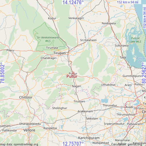
Puttūr GPS coordinates[2]
13° 26' 30.804" North, 79° 33' 11.304" East
| Map corner | latitude | longitude |
|---|---|---|
| Upper-left | 14.12476°, | 78.85002° |
| Center: | 13.44189°, | 79.55314° |
| Lower-right: | 12.75707°, | 80.25627° |
| Map W x H: | 152.1×152.1 km | = 94.5×94.5mi |
| max Lat: | 34.9274° ⇑84.4% North |
| Puttūr: | 13.44189° |
| min Lat: | ⇓15.6% South 8.09008° |
| min Long | Puttūr | max Long |
| 68.82655° | 79.55314° | 96.81° |
| W 64.3%⇐ | ⇒35.7% E |
Elevation
Elevation of Puttūr is 152 m = 499 ft, and this is 143.6 m = 471 ft below average elevation for this country.
| Max E: |
3681 m = 12077 ft | 59.3% |
| Avg. | 295.6 m = 970 ft | |
| Puttūr | 152 m = 499 ft | |
Min E: |
1 m = 3 ft | 40.7% |
See also: India elevation on elevation.city.
Geographical zone
Puttūr is located in North Torrid zone (between Equator and Tropic of Cancer). Distance of this Northern Tropic circle is 1111.3 km =690.5 mi to North.| Distance of | km | miles | from Puttūr |
|---|---|---|---|
| North Pole | 8512.5 | 5289.4 | to North |
| Arctic Circle | 5906.6 | 3670.2 | to North |
| Tropic Cancer | 1111.3 | 690.5 | to North |
| Equator | 1494.6 | 928.7 | to South |


Nearby cities:
15 places around Puttūr: (largest is in red/bold)
• Akkarampalle
27.3 km =17 mi,  328°
328°
• Arakkonam
41.7 km =25.9 mi,  162°
162°
• Chittoor
55.8 km =34.7 mi,  242°
242°
• Nagari
13.8 km =8.6 mi,  165°
165°
• Narasingāpuram
31.5 km =19.6 mi,  305°
305°
• Nārāyanavanam
4.3 km =2.7 mi,  115°
115°
• Pallipattu
16.4 km =10.2 mi,  225°
225°
• Pākāla
47.4 km =29.5 mi,  270°
270°
• Renigunta
23.7 km =14.7 mi,  349°
349°
• Rāmāpuram
55.1 km =34.2 mi, 226°
• Sholinghur
38.8 km =24.1 mi,  201°
201°
• Thiruthani
30.4 km =18.9 mi, 166°
• Tirumala
34.7 km =21.6 mi,  320°
320°
• Tirupati
25.9 km =16.1 mi, 326°
• Tiruvallur
50.8 km =31.6 mi,  130°
130°
Sources, notices
• [Note1] Compared only with cities in India existing in our database
• [Src1] Map data: © OpenStreetMap contributors (CC-BY-SA)
• [Src2] Other city data from geonames.org with taken over terms of usage.
• [Src3] Geographical zone / Annual Mean Temperature by Robert A. Rohde @ Wikipedia
