Kuttampuzha geodata
Kuttampuzha (Kerala) is a populated place; located in India in Asia/Kolkata (GMT+5.5) time zone. With population of 25,436 people, there are 1671 cities with bigger population in this country. Compared to other cities in India, 95.9% of cities are located further ↑North; 65.8% of cities are located further →East and 79.9% of cities have higher elevation than Kuttampuzha. Note1


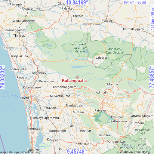
Kuttampuzha GPS coordinates[2]
10° 9' 1.188" North, 76° 44' 7.584" East
| Map corner | latitude | longitude |
|---|---|---|
| Upper-left | 10.84169°, | 76.03232° |
| Center: | 10.15033°, | 76.73544° |
| Lower-right: | 9.45748°, | 77.43857° |
| Map W x H: | 153.9×153.9 km | = 95.6×95.6mi |
| max Lat: | 34.9274° ⇑95.9% North |
| Kuttampuzha: | 10.15033° |
| min Lat: | ⇓4.1% South 8.09008° |
| min Long | Kuttampuzha | max Long |
| 68.82655° | 76.73544° | 96.81° |
| W 34.2%⇐ | ⇒65.8% E |
Elevation
Elevation of Kuttampuzha is 48 m = 157 ft, and this is 247.6 m = 812 ft below average elevation for this country.
| Max E: |
3681 m = 12077 ft | 79.9% |
| Avg. | 295.6 m = 970 ft | |
| Kuttampuzha | 48 m = 157 ft | |
Min E: |
1 m = 3 ft | 20.1% |
See also: India elevation on elevation.city.
Geographical zone
Kuttampuzha is located in North Torrid zone (between Equator and Tropic of Cancer). Distance of Equator is 1128.6 km =701.3 mi to South.| Distance of | km | miles | from Kuttampuzha |
|---|---|---|---|
| North Pole | 8878.5 | 5516.8 | to North |
| Arctic Circle | 6272.6 | 3897.6 | to North |
| Tropic Cancer | 1477.3 | 918 | to North |
| Equator | 1128.6 | 701.3 | to South |


Nearby cities:
15 places around Kuttampuzha: (largest is in red/bold)
• Aluva
42.3 km =26.3 mi,  263°
263°
• Alwaye
41.9 km =26 mi, 263°
• Angamāli
38.3 km =23.8 mi,  276°
276°
• Idukki
41.9 km =26 mi,  142°
142°
• Kalamassery
45.9 km =28.5 mi, 257°
• Kizhake Chālakudi
46.6 km =29 mi,  291°
291°
• Kotamangalam
15.1 km =9.4 mi,  230°
230°
• Munnar
36.4 km =22.6 mi,  100°
100°
• Muvattupuzha
25.9 km =16.1 mi,  223°
223°
• Mūvattupula
25.3 km =15.7 mi, 223°
• Perumbavoor
29.1 km =18.1 mi, 260°
• Perumpāvūr
28.6 km =17.8 mi, 262°
• Piravam
40.7 km =25.3 mi, 219°
• Rāmamangalam
35.3 km =21.9 mi, 226°
• Valparai
30.7 km =19.1 mi,  50°
50°
Sources, notices
• [Note1] Compared only with cities in India existing in our database
• [Src1] Map data: © OpenStreetMap contributors (CC-BY-SA)
• [Src2] Other city data from geonames.org with taken over terms of usage.
• [Src3] Geographical zone / Annual Mean Temperature by Robert A. Rohde @ Wikipedia
