Pennādam geodata
Pennādam (Tamil Nadu) is a populated place; located in India in Asia/Kolkata (GMT+5.5) time zone. With population of 17,662 people, there are 2224 cities with bigger population in this country. Compared to other cities in India, 91.6% of cities are located further ↑North; 61.3% of cities are located further ←West and 78.9% of cities have higher elevation than Pennādam. Note1


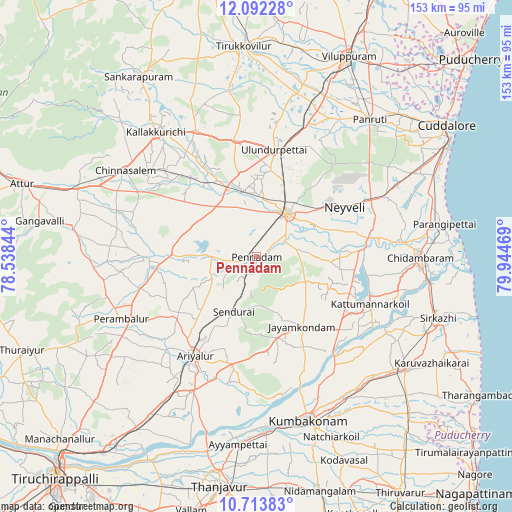
Pennādam GPS coordinates[2]
11° 24' 14.004" North, 79° 14' 29.616" East
| Map corner | latitude | longitude |
|---|---|---|
| Upper-left | 12.09228°, | 78.53844° |
| Center: | 11.40389°, | 79.24156° |
| Lower-right: | 10.71383°, | 79.94469° |
| Map W x H: | 153.3×153.3 km | = 95.3×95.3mi |
| max Lat: | 34.9274° ⇑91.6% North |
| Pennādam: | 11.40389° |
| min Lat: | ⇓8.4% South 8.09008° |
| min Long | Pennādam | max Long |
| 68.82655° | 79.24156° | 96.81° |
| W 61.3%⇐ | ⇒38.7% E |
Elevation
Elevation of Pennādam is 52 m = 171 ft, and this is 243.6 m = 799 ft below average elevation for this country.
| Max E: |
3681 m = 12077 ft | 78.9% |
| Avg. | 295.6 m = 970 ft | |
| Pennādam | 52 m = 171 ft | |
Min E: |
1 m = 3 ft | 21.1% |
See also: India elevation on elevation.city.
Geographical zone
Pennādam is located in North Torrid zone (between Equator and Tropic of Cancer). Distance of Equator is 1268 km =787.9 mi to South.| Distance of | km | miles | from Pennādam |
|---|---|---|---|
| North Pole | 8739.1 | 5430.2 | to North |
| Arctic Circle | 6133.2 | 3811 | to North |
| Tropic Cancer | 1337.9 | 831.3 | to North |
| Equator | 1268 | 787.9 | to South |


Nearby cities:
15 places around Pennādam: (largest is in red/bold)
• Aduthurai
50.5 km =31.4 mi,  148°
148°
• Ariyalūr
34.6 km =21.5 mi,  211°
211°
• Chidambaram
49 km =30.4 mi,  90°
90°
• Chinna Salem
47.5 km =29.5 mi,  302°
302°
• Jayamkondacholapuram
25.1 km =15.6 mi, 147°
• Kallakkurichchi
48.4 km =30.1 mi,  320°
320°
• Kumbakonam
51.8 km =32.2 mi,  161°
161°
• Kurinjippādi
41.4 km =25.7 mi,  66°
66°
• Kīl Bhuvanagiri
44.5 km =27.7 mi,  84°
84°
• Māttūr
10.1 km =6.3 mi,  204°
204°
• Perambalur
43.4 km =27 mi,  244°
244°
• Srīmushnam
17.7 km =11 mi, 90°
• Swāmimalai
50.6 km =31.4 mi,  169°
169°
• Thiruvidaimaruthur
50.6 km =31.4 mi, 152°
• Vriddhāchalam
15.6 km =9.7 mi,  35°
35°
Sources, notices
• [Note1] Compared only with cities in India existing in our database
• [Src1] Map data: © OpenStreetMap contributors (CC-BY-SA)
• [Src2] Other city data from geonames.org with taken over terms of usage.
• [Src3] Geographical zone / Annual Mean Temperature by Robert A. Rohde @ Wikipedia
