Perambalur geodata
Perambalur (Tamil Nadu) is a populated place; located in India in Asia/Kolkata (GMT+5.5) time zone. With population of 30,799 people, there are 1411 cities with bigger population in this country. Compared to other cities in India, 92.3% of cities are located further ↑North; 57.9% of cities are located further ←West and 64.4% of cities have higher elevation than Perambalur. Note1


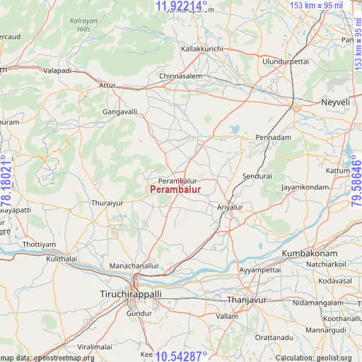
Perambalur GPS coordinates[2]
11° 13' 59.988" North, 78° 52' 59.988" East
| Map corner | latitude | longitude |
|---|---|---|
| Upper-left | 11.92214°, | 78.18021° |
| Center: | 11.23333°, | 78.88333° |
| Lower-right: | 10.54287°, | 79.58646° |
| Map W x H: | 153.4×153.4 km | = 95.3×95.3mi |
| max Lat: | 34.9274° ⇑92.3% North |
| Perambalur: | 11.23333° |
| min Lat: | ⇓7.7% South 8.09008° |
| min Long | Perambalur | max Long |
| 68.82655° | 78.88333° | 96.81° |
| W 57.9%⇐ | ⇒42.1% E |
Elevation
Elevation of Perambalur is 124 m = 407 ft, and this is 171.6 m = 563 ft below average elevation for this country.
| Max E: |
3681 m = 12077 ft | 64.4% |
| Avg. | 295.6 m = 970 ft | |
| Perambalur | 124 m = 407 ft | |
Min E: |
1 m = 3 ft | 35.6% |
See also: India elevation on elevation.city.
Geographical zone
Perambalur is located in North Torrid zone (between Equator and Tropic of Cancer). Distance of Equator is 1249 km =776.1 mi to South.| Distance of | km | miles | from Perambalur |
|---|---|---|---|
| North Pole | 8758 | 5442 | to North |
| Arctic Circle | 6152.1 | 3822.7 | to North |
| Tropic Cancer | 1356.9 | 843.1 | to North |
| Equator | 1249 | 776.1 | to South |


Nearby cities:
15 places around Perambalur: (largest is in red/bold)
• Ariyalūr
23.5 km =14.6 mi,  116°
116°
• Arumbāvūr
23.5 km =14.6 mi,  314°
314°
• Chinna Salem
44.6 km =27.7 mi,  358°
358°
• Gangavalli
38.9 km =24.2 mi,  319°
319°
• Lalgudi
40.5 km =25.2 mi,  189°
189°
• Mettuppālaiyam
47.9 km =29.8 mi,  261°
261°
• Māttūr
36.2 km =22.5 mi,  74°
74°
• Pennādam
43.4 km =27 mi,  64°
64°
• Pullambādi
32.6 km =20.3 mi,  174°
174°
• Thirukattupalli
44 km =27.3 mi, 169°
• Thiruvaiyaru
45.7 km =28.4 mi,  148°
148°
• Turaiyūr
32.4 km =20.1 mi,  253°
253°
• Tāttayyangārpettai
48.9 km =30.4 mi, 255°
• Uppiliyapuram
40.4 km =25.1 mi,  274°
274°
• Vīraganūr
31.4 km =19.5 mi,  329°
329°
Sources, notices
• [Note1] Compared only with cities in India existing in our database
• [Src1] Map data: © OpenStreetMap contributors (CC-BY-SA)
• [Src2] Other city data from geonames.org with taken over terms of usage.
• [Src3] Geographical zone / Annual Mean Temperature by Robert A. Rohde @ Wikipedia
