Munnar geodata
Munnar (Kerala) is a populated place; located in India in Asia/Kolkata (GMT+5.5) time zone. With population of 68,000 people, there are 639 cities with bigger population in this country. Compared to other cities in India, 96.2% of cities are located further ↑North; 62.4% of cities are located further →East and 97.6% of cities have lower elevation than Munnar. Note1


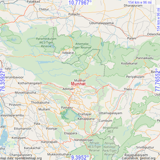
Munnar GPS coordinates[2]
10° 5' 17.448" North, 77° 3' 44.604" East
| Map corner | latitude | longitude |
|---|---|---|
| Upper-left | 10.77967°, | 76.35927° |
| Center: | 10.08818°, | 77.06239° |
| Lower-right: | 9.3952°, | 77.76552° |
| Map W x H: | 153.9×153.9 km | = 95.6×95.6mi |
| max Lat: | 34.9274° ⇑96.2% North |
| Munnar: | 10.08818° |
| min Lat: | ⇓3.8% South 8.09008° |
| min Long | Munnar | max Long |
| 68.82655° | 77.06239° | 96.81° |
| W 37.6%⇐ | ⇒62.4% E |
Elevation
Elevation of Munnar is 1470 m = 4823 ft, and this is 1174.4 m = 3853 ft above average elevation for this country.
| Max E: |
3681 m = 12077 ft | 2.4% |
| Munnar | 1470 m 4823 ft | |
| Avg. | 295.6 m = 970 ft | |
Min E: |
1 m = 3 ft | 97.6% |
See also: Munnar elevation on elevation.city.
Geographical zone
Munnar is located in North Torrid zone (between Equator and Tropic of Cancer). Distance of Equator is 1121.7 km =697 mi to South.| Distance of | km | miles | from Munnar |
|---|---|---|---|
| North Pole | 8885.4 | 5521.1 | to North |
| Arctic Circle | 6279.5 | 3901.9 | to North |
| Tropic Cancer | 1484.2 | 922.2 | to North |
| Equator | 1121.7 | 697 | to South |


Nearby cities:
15 places around Munnar: (largest is in red/bold)
• Bodināyakkanūr
32.6 km =20.3 mi,  105°
105°
• Chinnamanūr
44.5 km =27.7 mi,  128°
128°
• Cumbum
46.1 km =28.6 mi,  148°
148°
• Dhali
48.9 km =30.4 mi,  16°
16°
• Gudalur
50 km =31.1 mi,  155°
155°
• Idukki
28.5 km =17.7 mi,  201°
201°
• Kodaikānāl
49.7 km =30.9 mi,  70°
70°
• Kombai
37 km =23 mi,  136°
136°
• Kotamangalam
47.6 km =29.6 mi,  266°
266°
• Kuttampuzha
36.4 km =22.6 mi,  280°
280°
• Marayur
23.6 km =14.7 mi,  27°
27°
• Periyakulam
52.8 km =32.8 mi,  85°
85°
• Teni
46.3 km =28.8 mi,  100°
100°
• Uttamapālaiyam
42.6 km =26.5 mi, 137°
• Valparai
29.2 km =18.1 mi,  335°
335°
Sources, notices
• [Note1] Compared only with cities in India existing in our database
• [Src1] Map data: © OpenStreetMap contributors (CC-BY-SA)
• [Src2] Other city data from geonames.org with taken over terms of usage.
• [Src3] Geographical zone / Annual Mean Temperature by Robert A. Rohde @ Wikipedia
