Marayur geodata
Marayur (Kerala) is a populated place; located in India in Asia/Kolkata (GMT+5.5) time zone. With population of 25,000 people, there are 1701 cities with bigger population in this country. Compared to other cities in India, 95.6% of cities are located further ↑North; 61.4% of cities are located further →East and 96.1% of cities have lower elevation than Marayur. Note1


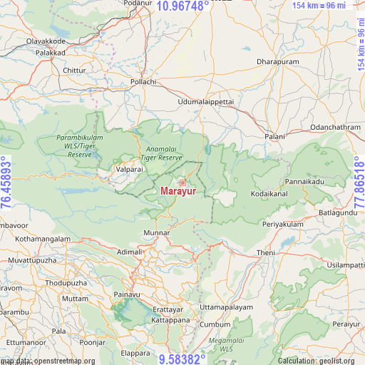
Marayur GPS coordinates[2]
10° 16' 35.076" North, 77° 9' 43.38" East
| Map corner | latitude | longitude |
|---|---|---|
| Upper-left | 10.96748°, | 76.45893° |
| Center: | 10.27641°, | 77.16205° |
| Lower-right: | 9.58382°, | 77.86518° |
| Map W x H: | 153.8×153.9 km | = 95.6×95.6mi |
| max Lat: | 34.9274° ⇑95.6% North |
| Marayur: | 10.27641° |
| min Lat: | ⇓4.4% South 8.09008° |
| min Long | Marayur | max Long |
| 68.82655° | 77.16205° | 96.81° |
| W 38.6%⇐ | ⇒61.4% E |
Elevation
Elevation of Marayur is 989 m = 3245 ft, and this is 693.4 m = 2275 ft above average elevation for this country.
| Max E: |
3681 m = 12077 ft | 3.9% |
| Marayur | 989 m 3245 ft | |
| Avg. | 295.6 m = 970 ft | |
Min E: |
1 m = 3 ft | 96.1% |
See also: India elevation on elevation.city.
Geographical zone
Marayur is located in North Torrid zone (between Equator and Tropic of Cancer). Distance of Equator is 1142.6 km =710 mi to South.| Distance of | km | miles | from Marayur |
|---|---|---|---|
| North Pole | 8864.4 | 5508.1 | to North |
| Arctic Circle | 6258.5 | 3888.9 | to North |
| Tropic Cancer | 1463.3 | 909.3 | to North |
| Equator | 1142.6 | 710 | to South |


Nearby cities:
15 places around Marayur: (largest is in red/bold)
• Anamalais
42.2 km =26.2 mi,  323°
323°
• Ayakudi
46.8 km =29.1 mi,  65°
65°
• Bodināyakkanūr
35.9 km =22.3 mi,  145°
145°
• Dhali
26.2 km =16.3 mi,  6°
6°
• Kodaikānāl
36 km =22.4 mi,  96°
96°
• Kumaralingam
31.3 km =19.4 mi,  40°
40°
• Kuttampuzha
48.7 km =30.3 mi,  253°
253°
• Munnar
23.6 km =14.7 mi,  207°
207°
• Palani
43.8 km =27.2 mi,  63°
63°
• Periyakulam
45.1 km =28 mi,  112°
112°
• Pollachi
45.7 km =28.4 mi,  338°
338°
• Teni
45.4 km =28.2 mi,  130°
130°
• Udumalaippettai
35.9 km =22.3 mi,  15°
15°
• Valparai
23.7 km =14.7 mi,  283°
283°
• Vettaikkaranpudur
41.8 km =26 mi, 319°
Sources, notices
• [Note1] Compared only with cities in India existing in our database
• [Src1] Map data: © OpenStreetMap contributors (CC-BY-SA)
• [Src2] Other city data from geonames.org with taken over terms of usage.
• [Src3] Geographical zone / Annual Mean Temperature by Robert A. Rohde @ Wikipedia
