Māngrol geodata
Māngrol (Gujarat) is a populated place; located in India in Asia/Kolkata (GMT+5.5) time zone. With population of 58,989 people, there are 744 cities with bigger population in this country. Compared to other cities in India, 61.1% of cities are located further ↑North; 99.4% of cities are located further →East and 88.1% of cities have higher elevation than Māngrol. Note1


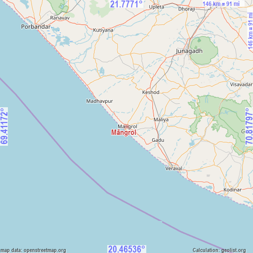
Māngrol GPS coordinates[2]
21° 7' 21.648" North, 70° 6' 53.424" East
| Map corner | latitude | longitude |
|---|---|---|
| Upper-left | 21.7771°, | 69.41172° |
| Center: | 21.12268°, | 70.11484° |
| Lower-right: | 20.46536°, | 70.81797° |
| Map W x H: | 145.9×145.9 km | = 90.7×90.7mi |
| max Lat: | 34.9274° ⇑61.1% North |
| Māngrol: | 21.12268° |
| min Lat: | ⇓38.9% South 8.09008° |
| min Long | Māngrol | max Long |
| 68.82655° | 70.11484° | 96.81° |
| W 0.6%⇐ | ⇒99.4% E |
Elevation
Elevation of Māngrol is 22 m = 72 ft, and this is 273.6 m = 898 ft below average elevation for this country.
| Max E: |
3681 m = 12077 ft | 88.1% |
| Avg. | 295.6 m = 970 ft | |
| Māngrol | 22 m = 72 ft | |
Min E: |
1 m = 3 ft | 11.9% |
See also: Māngrol elevation on elevation.city.
Geographical zone
Māngrol is located in North Torrid zone (between Equator and Tropic of Cancer). Distance of this Northern Tropic circle is 257.3 km =159.9 mi to North.| Distance of | km | miles | from Māngrol |
|---|---|---|---|
| North Pole | 7658.4 | 4758.7 | to North |
| Arctic Circle | 5052.6 | 3139.5 | to North |
| Tropic Cancer | 257.3 | 159.9 | to North |
| Equator | 2348.6 | 1459.4 | to South |


Nearby cities:
15 places around Māngrol: (largest is in red/bold)
• Bilkha
61.6 km =38.3 mi,  54°
54°
• Bāntva
40.8 km =25.4 mi,  354°
354°
• Dhorāji
76.3 km =47.4 mi,  27°
27°
• Jetalsar
80.9 km =50.3 mi,  36°
36°
• Jūnāgadh
56.8 km =35.3 mi, 38°
• Keshod
24.4 km =15.2 mi, 34°
• Kodīnar
71.1 km =44.2 mi,  120°
120°
• Kutiyāna
57.4 km =35.7 mi, 346°
• Mendarda
40.4 km =25.1 mi,  56°
56°
• Mānāvadar
41.8 km =26 mi,  3°
3°
• Porbandar
78 km =48.5 mi,  317°
317°
• Rānāvāv
73.5 km =45.7 mi,  328°
328°
• Upleta
70.8 km =44 mi,  14°
14°
• Verāval
35.5 km =22.1 mi,  132°
132°
• Vīsāvadar
70.1 km =43.6 mi,  69°
69°
Sources, notices
• [Note1] Compared only with cities in India existing in our database
• [Src1] Map data: © OpenStreetMap contributors (CC-BY-SA)
• [Src2] Other city data from geonames.org with taken over terms of usage.
• [Src3] Geographical zone / Annual Mean Temperature by Robert A. Rohde @ Wikipedia
