Mendarda geodata
Mendarda (Gujarat) is a populated place; located in India in Asia/Kolkata (GMT+5.5) time zone. With population of 17,166 people, there are 2270 cities with bigger population in this country. Compared to other cities in India, 59.9% of cities are located further ↑North; 99.1% of cities are located further →East and 70.2% of cities have higher elevation than Mendarda. Note1


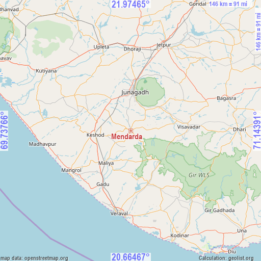
Mendarda GPS coordinates[2]
21° 19' 16.032" North, 70° 26' 26.808" East
| Map corner | latitude | longitude |
|---|---|---|
| Upper-left | 21.97465°, | 69.73766° |
| Center: | 21.32112°, | 70.44078° |
| Lower-right: | 20.66467°, | 71.14391° |
| Map W x H: | 145.7×145.7 km | = 90.5×90.5mi |
| max Lat: | 34.9274° ⇑59.9% North |
| Mendarda: | 21.32112° |
| min Lat: | ⇓40.1% South 8.09008° |
| min Long | Mendarda | max Long |
| 68.82655° | 70.44078° | 96.81° |
| W 0.9%⇐ | ⇒99.1% E |
Elevation
Elevation of Mendarda is 91 m = 299 ft, and this is 204.6 m = 671 ft below average elevation for this country.
| Max E: |
3681 m = 12077 ft | 70.2% |
| Avg. | 295.6 m = 970 ft | |
| Mendarda | 91 m = 299 ft | |
Min E: |
1 m = 3 ft | 29.8% |
See also: India elevation on elevation.city.
Geographical zone
Mendarda is located in North Torrid zone (between Equator and Tropic of Cancer). Distance of this Northern Tropic circle is 235.2 km =146.1 mi to North.| Distance of | km | miles | from Mendarda |
|---|---|---|---|
| North Pole | 7636.4 | 4745 | to North |
| Arctic Circle | 5030.5 | 3125.8 | to North |
| Tropic Cancer | 235.2 | 146.1 | to North |
| Equator | 2370.7 | 1473.1 | to South |


Nearby cities:
15 places around Mendarda: (largest is in red/bold)
• Bagasra
56.4 km =35 mi,  70°
70°
• Bilkha
21.3 km =13.2 mi,  51°
51°
• Bāntva
42.1 km =26.2 mi,  296°
296°
• Dhorāji
45.9 km =28.5 mi,  1°
1°
• Dhāri
60.7 km =37.7 mi,  89°
89°
• Jetalsar
45.4 km =28.2 mi,  18°
18°
• Jetpur
51.8 km =32.2 mi, 21°
• Jūnāgadh
22.2 km =13.8 mi,  5°
5°
• Keshod
20 km =12.4 mi,  264°
264°
• Kutiyāna
58 km =36 mi,  305°
305°
• Māngrol
40.4 km =25.1 mi,  236°
236°
• Mānāvadar
37 km =23 mi, 302°
• Upleta
49.4 km =30.7 mi,  340°
340°
• Verāval
46.6 km =29 mi,  189°
189°
• Vīsāvadar
32.1 km =19.9 mi, 86°
Sources, notices
• [Note1] Compared only with cities in India existing in our database
• [Src1] Map data: © OpenStreetMap contributors (CC-BY-SA)
• [Src2] Other city data from geonames.org with taken over terms of usage.
• [Src3] Geographical zone / Annual Mean Temperature by Robert A. Rohde @ Wikipedia
