Vīsāvadar geodata
Vīsāvadar (Gujarat) is a populated place; located in India in Asia/Kolkata (GMT+5.5) time zone. With population of 18,382 people, there are 2173 cities with bigger population in this country. Compared to other cities in India, 59.8% of cities are located further ↑North; 98.8% of cities are located further →East and 61.5% of cities have higher elevation than Vīsāvadar. Note1


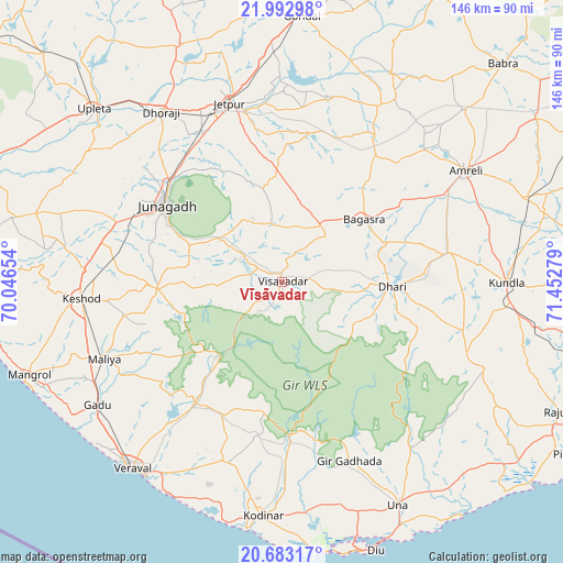
Vīsāvadar GPS coordinates[2]
21° 20' 22.344" North, 70° 44' 58.776" East
| Map corner | latitude | longitude |
|---|---|---|
| Upper-left | 21.99298°, | 70.04654° |
| Center: | 21.33954°, | 70.74966° |
| Lower-right: | 20.68317°, | 71.45279° |
| Map W x H: | 145.6×145.6 km | = 90.5×90.5mi |
| max Lat: | 34.9274° ⇑59.8% North |
| Vīsāvadar: | 21.33954° |
| min Lat: | ⇓40.2% South 8.09008° |
| min Long | Vīsāvadar | max Long |
| 68.82655° | 70.74966° | 96.81° |
| W 1.2%⇐ | ⇒98.8% E |
Elevation
Elevation of Vīsāvadar is 140 m = 459 ft, and this is 155.6 m = 510 ft below average elevation for this country.
| Max E: |
3681 m = 12077 ft | 61.5% |
| Avg. | 295.6 m = 970 ft | |
| Vīsāvadar | 140 m = 459 ft | |
Min E: |
1 m = 3 ft | 38.5% |
See also: India elevation on elevation.city.
Geographical zone
Vīsāvadar is located in North Torrid zone (between Equator and Tropic of Cancer). Distance of this Northern Tropic circle is 233.2 km =144.9 mi to North.| Distance of | km | miles | from Vīsāvadar |
|---|---|---|---|
| North Pole | 7634.3 | 4743.7 | to North |
| Arctic Circle | 5028.4 | 3124.5 | to North |
| Tropic Cancer | 233.2 | 144.9 | to North |
| Equator | 2372.7 | 1474.3 | to South |


Nearby cities:
15 places around Vīsāvadar: (largest is in red/bold)
• Amreli
55.9 km =34.7 mi,  58°
58°
• Bagasra
26.9 km =16.7 mi,  52°
52°
• Bilkha
19.1 km =11.9 mi,  306°
306°
• Chalāla
43.9 km =27.3 mi,  79°
79°
• Dhorāji
53.7 km =33.4 mi,  324°
324°
• Dhāri
28.7 km =17.8 mi,  92°
92°
• Jetalsar
44.8 km =27.8 mi,  336°
336°
• Jetpur
48 km =29.8 mi, 344°
• Jūnāgadh
36.1 km =22.4 mi,  303°
303°
• Keshod
52.1 km =32.4 mi,  265°
265°
• Kodīnar
60.9 km =37.8 mi,  184°
184°
• Kundla
57.7 km =35.9 mi, 89°
• Mendarda
32.1 km =19.9 mi, 266°
• Savarkundla
57.4 km =35.7 mi, 90°
• Verāval
62.2 km =38.6 mi,  219°
219°
Sources, notices
• [Note1] Compared only with cities in India existing in our database
• [Src1] Map data: © OpenStreetMap contributors (CC-BY-SA)
• [Src2] Other city data from geonames.org with taken over terms of usage.
• [Src3] Geographical zone / Annual Mean Temperature by Robert A. Rohde @ Wikipedia
