Mālvan geodata
Mālvan (Maharashtra) is a populated place; located in India in Asia/Kolkata (GMT+5.5) time zone. With population of 18,858 people, there are 2139 cities with bigger population in this country. Compared to other cities in India, 77.9% of cities are located further ↑North; 92.7% of cities are located further →East and 92.8% of cities have higher elevation than Mālvan. Note1


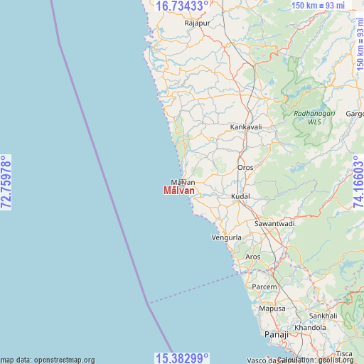
Mālvan GPS coordinates[2]
16° 3' 35.316" North, 73° 27' 46.44" East
| Map corner | latitude | longitude |
|---|---|---|
| Upper-left | 16.73433°, | 72.75978° |
| Center: | 16.05981°, | 73.4629° |
| Lower-right: | 15.38299°, | 74.16603° |
| Map W x H: | 150.3×150.3 km | = 93.4×93.4mi |
| max Lat: | 34.9274° ⇑77.9% North |
| Mālvan: | 16.05981° |
| min Lat: | ⇓22.1% South 8.09008° |
| min Long | Mālvan | max Long |
| 68.82655° | 73.4629° | 96.81° |
| W 7.3%⇐ | ⇒92.7% E |
Elevation
Elevation of Mālvan is 14 m = 46 ft, and this is 281.6 m = 924 ft below average elevation for this country.
| Max E: |
3681 m = 12077 ft | 92.8% |
| Avg. | 295.6 m = 970 ft | |
| Mālvan | 14 m = 46 ft | |
Min E: |
1 m = 3 ft | 7.2% |
See also: India elevation on elevation.city.
Geographical zone
Mālvan is located in North Torrid zone (between Equator and Tropic of Cancer). Distance of this Northern Tropic circle is 820.2 km =509.6 mi to North.| Distance of | km | miles | from Mālvan |
|---|---|---|---|
| North Pole | 8221.4 | 5108.5 | to North |
| Arctic Circle | 5615.5 | 3489.3 | to North |
| Tropic Cancer | 820.2 | 509.6 | to North |
| Equator | 1785.7 | 1109.6 | to South |


Nearby cities:
15 places around Mālvan: (largest is in red/bold)
• Arambol
48.9 km =30.4 mi,  148°
148°
• Baga
63.3 km =39.3 mi, 150°
• Calangute
65.3 km =40.6 mi, 151°
• Chapora
58.8 km =36.5 mi, 149°
• Colovale
61 km =37.9 mi,  140°
140°
• Guirim
65.2 km =40.5 mi, 145°
• Kankauli
35.1 km =21.8 mi,  49°
49°
• Kudāl
24.7 km =15.3 mi,  102°
102°
• Morjim
56.1 km =34.9 mi, 148°
• Māpuca
63.9 km =39.7 mi, 144°
• Pernem
51.6 km =32.1 mi, 136°
• Solim
59.2 km =36.8 mi, 146°
• Sāvantvādi
42.1 km =26.2 mi,  114°
114°
• Vagator
59.6 km =37 mi, 149°
• Vengurla
28.5 km =17.7 mi, 140°
Sources, notices
• [Note1] Compared only with cities in India existing in our database
• [Src1] Map data: © OpenStreetMap contributors (CC-BY-SA)
• [Src2] Other city data from geonames.org with taken over terms of usage.
• [Src3] Geographical zone / Annual Mean Temperature by Robert A. Rohde @ Wikipedia
