Kārsiyāng geodata
Kārsiyāng (West Bengal) is a populated place; located in India in Asia/Kolkata (GMT+5.5) time zone. With population of 46,427 people, there are 951 cities with bigger population in this country. Compared to other cities in India, 77.4% of cities are located further ↓South; 92.6% of cities are located further ←West and 97.7% of cities have lower elevation than Kārsiyāng. Note1


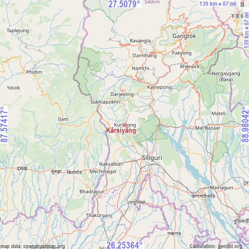
Kārsiyāng GPS coordinates[2]
26° 52' 57.036" North, 88° 16' 38.244" East
| Map corner | latitude | longitude |
|---|---|---|
| Upper-left | 27.5079°, | 87.57417° |
| Center: | 26.88251°, | 88.27729° |
| Lower-right: | 26.25364°, | 88.98042° |
| Map W x H: | 139.5×139.5 km | = 86.7×86.7mi |
| max Lat: | 34.9274° ⇑22.6% North |
| Kārsiyāng: | 26.88251° |
| min Lat: | ⇓77.4% South 8.09008° |
| min Long | Kārsiyāng | max Long |
| 68.82655° | 88.27729° | 96.81° |
| W 92.6%⇐ | ⇒7.4% E |
Elevation
Elevation of Kārsiyāng is 1501 m = 4925 ft, and this is 1205.4 m = 3955 ft above average elevation for this country.
| Max E: |
3681 m = 12077 ft | 2.3% |
| Kārsiyāng | 1501 m 4925 ft | |
| Avg. | 295.6 m = 970 ft | |
Min E: |
1 m = 3 ft | 97.7% |
See also: Kārsiyāng elevation on elevation.city.
Geographical zone
Kārsiyāng is located in North temperate zone (between Tropic of Cancer and the Arctic Circle). Distance of this Northern Tropic circle is 383.1 km =238 mi to South.| Distance of | km | miles | from Kārsiyāng |
|---|---|---|---|
| North Pole | 7018 | 4360.8 | to North |
| Arctic Circle | 4412.1 | 2741.6 | to North |
| Tropic Cancer | 383.1 | 238 | to South |
| Equator | 2989.1 | 1857.3 | to South |


Nearby cities:
15 places around Kārsiyāng: (largest is in red/bold)
• Bagdogra
20.7 km =12.9 mi,  170°
170°
• Dārjiling
16.8 km =10.4 mi,  356°
356°
• Gyalshing
45.3 km =28.1 mi, 357°
• Jorethang
25.4 km =15.8 mi,  10°
10°
• Kalimpong, Крукети
26.6 km =16.5 mi,  43°
43°
• Kālimpong
28.7 km =17.8 mi, 43°
• Mirik
8.7 km =5.4 mi,  274°
274°
• Naksalbāri
22.9 km =14.2 mi,  194°
194°
• Namchi
32.6 km =20.3 mi,  15°
15°
• Naya Bāzār
27.9 km =17.3 mi,  352°
352°
• Odlābāri
35.3 km =21.9 mi,  98°
98°
• Rangpo
41.5 km =25.8 mi, 37°
• Siliguri
24.4 km =15.2 mi,  141°
141°
• Singtam
45 km =28 mi,  29°
29°
• Thākurganj
52.6 km =32.7 mi,  196°
196°
Sources, notices
• [Note1] Compared only with cities in India existing in our database
• [Src1] Map data: © OpenStreetMap contributors (CC-BY-SA)
• [Src2] Other city data from geonames.org with taken over terms of usage.
• [Src3] Geographical zone / Annual Mean Temperature by Robert A. Rohde @ Wikipedia
