Gyalshing geodata
Gyalshing (Sikkim) is a seat of a second-order administrative division; located in India in Asia/Kolkata (GMT+5.5) time zone. With population of 4,000 people, there are 3380 cities with bigger population in this country. Compared to other cities in India, 80.7% of cities are located further ↓South; 92.3% of cities are located further ←West and 97.1% of cities have lower elevation than Gyalshing. Note1


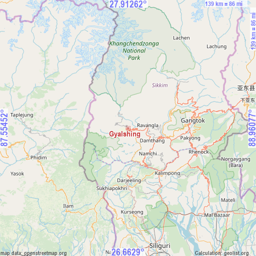
Gyalshing GPS coordinates[2]
27° 17' 22.272" North, 88° 15' 27.504" East
| Map corner | latitude | longitude |
|---|---|---|
| Upper-left | 27.91262°, | 87.55452° |
| Center: | 27.28952°, | 88.25764° |
| Lower-right: | 26.6629°, | 88.96077° |
| Map W x H: | 139×139 km | = 86.4×86.4mi |
| max Lat: | 34.9274° ⇑19.3% North |
| Gyalshing: | 27.28952° |
| min Lat: | ⇓80.7% South 8.09008° |
| min Long | Gyalshing | max Long |
| 68.82655° | 88.25764° | 96.81° |
| W 92.3%⇐ | ⇒7.7% E |
Elevation
Elevation of Gyalshing is 1294 m = 4245 ft, and this is 998.4 m = 3276 ft above average elevation for this country.
| Max E: |
3681 m = 12077 ft | 2.9% |
| Gyalshing | 1294 m 4245 ft | |
| Avg. | 295.6 m = 970 ft | |
Min E: |
1 m = 3 ft | 97.1% |
See also: India elevation on elevation.city.
Geographical zone
Gyalshing is located in North temperate zone (between Tropic of Cancer and the Arctic Circle). Distance of this Northern Tropic circle is 428.4 km =266.2 mi to South.| Distance of | km | miles | from Gyalshing |
|---|---|---|---|
| North Pole | 6972.8 | 4332.7 | to North |
| Arctic Circle | 4366.9 | 2713.5 | to North |
| Tropic Cancer | 428.4 | 266.2 | to South |
| Equator | 3034.3 | 1885.4 | to South |


Nearby cities:
15 places around Gyalshing: (largest is in red/bold)
• Bagdogra
65.8 km =40.9 mi,  175°
175°
• Dārjiling
28.5 km =17.7 mi, 178°
• Gangtok
35.3 km =21.9 mi,  83°
83°
• Jorethang
21.3 km =13.2 mi,  162°
162°
• Kalimpong, Крукети
32.9 km =20.4 mi,  142°
142°
• Kālimpong
32.5 km =20.2 mi, 138°
• Kārsiyāng
45.3 km =28.1 mi, 177°
• Mangan
35.8 km =22.2 mi,  46°
46°
• Mirik
45.1 km =28 mi,  188°
188°
• Namchi
17.4 km =10.8 mi, 142°
• Naya Bāzār
17.7 km =11 mi, 185°
• Odlābāri
62.4 km =38.8 mi, 143°
• Rangpo
30 km =18.6 mi,  114°
114°
• Siliguri
66.6 km =41.4 mi,  165°
165°
• Singtam
24.9 km =15.5 mi,  104°
104°
Sources, notices
• [Note1] Compared only with cities in India existing in our database
• [Src1] Map data: © OpenStreetMap contributors (CC-BY-SA)
• [Src2] Other city data from geonames.org with taken over terms of usage.
• [Src3] Geographical zone / Annual Mean Temperature by Robert A. Rohde @ Wikipedia
