Rangpo geodata
Rangpo (Sikkim) is a populated place; located in India in Asia/Kolkata (GMT+5.5) time zone. With population of 4,026 people, there are 3378 cities with bigger population in this country. Compared to other cities in India, 79.9% of cities are located further ↓South; 94.4% of cities are located further ←West and 67.8% of cities have lower elevation than Rangpo. Note1


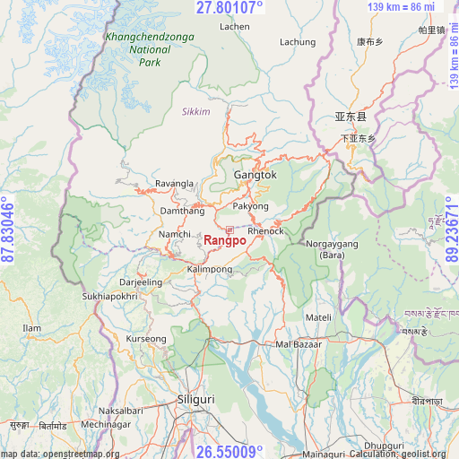
Rangpo GPS coordinates[2]
27° 10' 38.388" North, 88° 32' 0.888" East
| Map corner | latitude | longitude |
|---|---|---|
| Upper-left | 27.80107°, | 87.83046° |
| Center: | 27.17733°, | 88.53358° |
| Lower-right: | 26.55009°, | 89.23671° |
| Map W x H: | 139.1×139.1 km | = 86.4×86.4mi |
| max Lat: | 34.9274° ⇑20.1% North |
| Rangpo: | 27.17733° |
| min Lat: | ⇓79.9% South 8.09008° |
| min Long | Rangpo | max Long |
| 68.82655° | 88.53358° | 96.81° |
| W 94.4%⇐ | ⇒5.6% E |
Elevation
Elevation of Rangpo is 307 m = 1007 ft, and this is 11.4 m = 37 ft above average elevation for this country.
| Max E: |
3681 m = 12077 ft | 32.2% |
| Rangpo | 307 m 1007 ft | |
| Avg. | 295.6 m = 970 ft | |
Min E: |
1 m = 3 ft | 67.8% |
See also: India elevation on elevation.city.
Geographical zone
Rangpo is located in North temperate zone (between Tropic of Cancer and the Arctic Circle). Distance of this Northern Tropic circle is 415.9 km =258.4 mi to South.| Distance of | km | miles | from Rangpo |
|---|---|---|---|
| North Pole | 6985.2 | 4340.4 | to North |
| Arctic Circle | 4379.3 | 2721.2 | to North |
| Tropic Cancer | 415.9 | 258.4 | to South |
| Equator | 3021.8 | 1877.7 | to South |


Nearby cities:
15 places around Rangpo: (largest is in red/bold)
• Bagdogra
57.5 km =35.7 mi,  202°
202°
• Dārjiling
30.9 km =19.2 mi,  238°
238°
• Gangtok
18.2 km =11.3 mi,  25°
25°
• Gyalshing
30 km =18.6 mi,  294°
294°
• Jorethang
22.2 km =13.8 mi,  249°
249°
• Kalimpong, Крукети
15.2 km =9.4 mi,  207°
207°
• Kālimpong
13.2 km =8.2 mi, 205°
• Kārsiyāng
41.5 km =25.8 mi,  217°
217°
• Mangan
37 km =23 mi,  358°
358°
• Mirik
46.8 km =29.1 mi,  226°
226°
• Namchi
16.9 km =10.5 mi,  265°
265°
• Naya Bāzār
29.5 km =18.3 mi,  259°
259°
• Odlābāri
39.1 km =24.3 mi,  165°
165°
• Siliguri
53 km =32.9 mi,  191°
191°
• Singtam
7.1 km =4.4 mi,  333°
333°
Sources, notices
• [Note1] Compared only with cities in India existing in our database
• [Src1] Map data: © OpenStreetMap contributors (CC-BY-SA)
• [Src2] Other city data from geonames.org with taken over terms of usage.
• [Src3] Geographical zone / Annual Mean Temperature by Robert A. Rohde @ Wikipedia
