Jugsālai geodata
Jugsālai (Jharkhand) is a section of populated place; located in India in Asia/Kolkata (GMT+5.5) time zone. With population of 49,410 people, there are 898 cities with bigger population in this country. Compared to other cities in India, 50.1% of cities are located further ↑North; 87.5% of cities are located further ←West and 58.3% of cities have higher elevation than Jugsālai. Note1


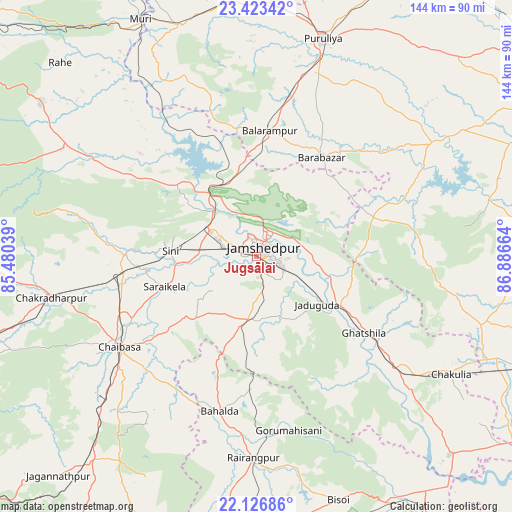
Jugsālai GPS coordinates[2]
22° 46' 36.048" North, 86° 11' 0.636" East
| Map corner | latitude | longitude |
|---|---|---|
| Upper-left | 23.42342°, | 85.48039° |
| Center: | 22.77668°, | 86.18351° |
| Lower-right: | 22.12686°, | 86.88664° |
| Map W x H: | 144.2×144.2 km | = 89.6×89.6mi |
| max Lat: | 34.9274° ⇑50.1% North |
| Jugsālai: | 22.77668° |
| min Lat: | ⇓49.9% South 8.09008° |
| min Long | Jugsālai | max Long |
| 68.82655° | 86.18351° | 96.81° |
| W 87.5%⇐ | ⇒12.5% E |
Elevation
Elevation of Jugsālai is 157 m = 515 ft, and this is 138.6 m = 455 ft below average elevation for this country.
| Max E: |
3681 m = 12077 ft | 58.3% |
| Avg. | 295.6 m = 970 ft | |
| Jugsālai | 157 m = 515 ft | |
Min E: |
1 m = 3 ft | 41.7% |
See also: Jugsālai elevation on elevation.city.
Geographical zone
Jugsālai is located in North Torrid zone (between Equator and Tropic of Cancer). Distance of this Northern Tropic circle is 73.4 km =45.6 mi to North.| Distance of | km | miles | from Jugsālai |
|---|---|---|---|
| North Pole | 7474.5 | 4644.4 | to North |
| Arctic Circle | 4868.6 | 3025.2 | to North |
| Tropic Cancer | 73.4 | 45.6 | to North |
| Equator | 2532.5 | 1573.6 | to South |


Nearby cities:
15 places around Jugsālai: (largest is in red/bold)
• Balarāmpur
35.9 km =22.3 mi,  6°
6°
• Chāndil
24.1 km =15 mi,  326°
326°
• Chāībāsa
46.5 km =28.9 mi,  237°
237°
• Ghātsīla
36.9 km =22.9 mi,  125°
125°
• Gobindpur
19.6 km =12.2 mi,  215°
215°
• Gopināthpur
16.8 km =10.4 mi, 221°
• Jamshedpur
2.9 km =1.8 mi,  3°
3°
• Kenda
57.7 km =35.9 mi,  36°
36°
• Kharsāwān
36.2 km =22.5 mi,  272°
272°
• Kuchaiburi
56.7 km =35.2 mi,  181°
181°
• Kālikāpur
20.8 km =12.9 mi,  148°
148°
• Kāndra
15.9 km =9.9 mi,  301°
301°
• Mushābani
40.7 km =25.3 mi,  136°
136°
• Saraikela
27.2 km =16.9 mi,  251°
251°
• Sini
24.5 km =15.2 mi, 274°
Sources, notices
• [Note1] Compared only with cities in India existing in our database
• [Src1] Map data: © OpenStreetMap contributors (CC-BY-SA)
• [Src2] Other city data from geonames.org with taken over terms of usage.
• [Src3] Geographical zone / Annual Mean Temperature by Robert A. Rohde @ Wikipedia
