Kāndra geodata
Kāndra (Jharkhand) is a populated place; located in India in Asia/Kolkata (GMT+5.5) time zone. With population of 6,902 people, there are 3219 cities with bigger population in this country. Compared to other cities in India, 50.6% of cities are located further ↓South; 87% of cities are located further ←West and 53.5% of cities have higher elevation than Kāndra. Note1


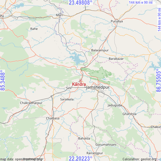
Kāndra GPS coordinates[2]
22° 51' 6.12" North, 86° 3' 6.912" East
| Map corner | latitude | longitude |
|---|---|---|
| Upper-left | 23.49808°, | 85.3488° |
| Center: | 22.8517°, | 86.05192° |
| Lower-right: | 22.20223°, | 86.75505° |
| Map W x H: | 144.1×144.1 km | = 89.5×89.5mi |
| max Lat: | 34.9274° ⇑49.4% North |
| Kāndra: | 22.8517° |
| min Lat: | ⇓50.6% South 8.09008° |
| min Long | Kāndra | max Long |
| 68.82655° | 86.05192° | 96.81° |
| W 87%⇐ | ⇒13% E |
Elevation
Elevation of Kāndra is 182 m = 597 ft, and this is 113.6 m = 373 ft below average elevation for this country.
| Max E: |
3681 m = 12077 ft | 53.5% |
| Avg. | 295.6 m = 970 ft | |
| Kāndra | 182 m = 597 ft | |
Min E: |
1 m = 3 ft | 46.5% |
See also: India elevation on elevation.city.
Geographical zone
Kāndra is located in North Torrid zone (between Equator and Tropic of Cancer). Distance of this Northern Tropic circle is 65 km =40.4 mi to North.| Distance of | km | miles | from Kāndra |
|---|---|---|---|
| North Pole | 7466.2 | 4639.3 | to North |
| Arctic Circle | 4860.3 | 3020 | to North |
| Tropic Cancer | 65 | 40.4 | to North |
| Equator | 2540.9 | 1578.8 | to South |


Nearby cities:
15 places around Kāndra: (largest is in red/bold)
• Balarāmpur
32.4 km =20.1 mi,  32°
32°
• Chakradharpur
47.6 km =29.6 mi,  245°
245°
• Chāndil
11.8 km =7.3 mi,  0°
0°
• Chāībāsa
42.2 km =26.2 mi,  217°
217°
• Ghātsīla
52.7 km =32.7 mi,  124°
124°
• Gobindpur
24.3 km =15.1 mi,  175°
175°
• Gopināthpur
21.1 km =13.1 mi,  173°
173°
• Jamshedpur
14.7 km =9.1 mi,  111°
111°
• Jhalidā
57.6 km =35.8 mi,  352°
352°
• Jugsālai
15.9 km =9.9 mi, 121°
• Kharsāwān
23.6 km =14.7 mi, 253°
• Kālikāpur
35.6 km =22.1 mi,  137°
137°
• Mushābani
56.2 km =34.9 mi,  132°
132°
• Saraikela
21 km =13 mi, 216°
• Sini
12.7 km =7.9 mi,  239°
239°
Sources, notices
• [Note1] Compared only with cities in India existing in our database
• [Src1] Map data: © OpenStreetMap contributors (CC-BY-SA)
• [Src2] Other city data from geonames.org with taken over terms of usage.
• [Src3] Geographical zone / Annual Mean Temperature by Robert A. Rohde @ Wikipedia
