Bauladu geodata
Bauladu (Sardinia) is a seat of a third-order administrative division; located in Italy in Europe/Rome (GMT+2) time zone. With population of 672 people, there are 8471 cities with bigger population in this country. Compared to other cities in Italy, 87.8% of cities are located further ↑North; 85.8% of cities are located further →East and 82.7% of cities have higher elevation than Bauladu. Note1


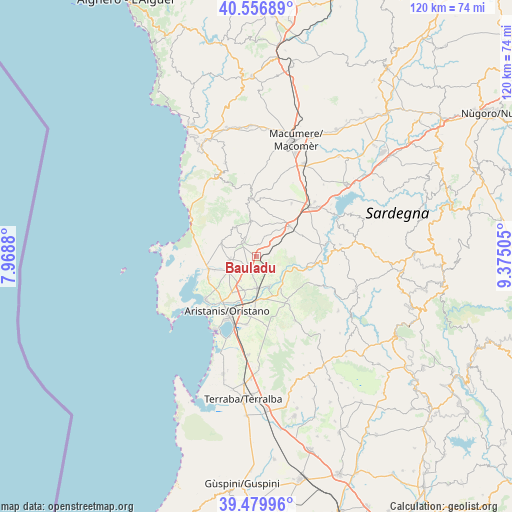
Bauladu GPS coordinates[2]
40° 1' 13.98" North, 8° 40' 18.912" East
| Map corner | latitude | longitude |
|---|---|---|
| Upper-left | 40.55689°, | 7.9688° |
| Center: | 40.02055°, | 8.67192° |
| Lower-right: | 39.47996°, | 9.37505° |
| Map W x H: | 119.7×119.7 km | = 74.4×74.4mi |
| max Lat: | 47.04031° ⇑87.8% North |
| Bauladu: | 40.02055° |
| min Lat: | ⇓12.2% South 35.50142° |
| min Long | Bauladu | max Long |
| 6.69888° | 8.67192° | 18.48682° |
| W 14.2%⇐ | ⇒85.8% E |
Elevation
Elevation of Bauladu is 39 m = 128 ft, and this is 267.7 m = 878 ft below average elevation for this country.
| Max E: |
2085 m = 6841 ft | 82.7% |
| Avg. | 306.7 m = 1006 ft | |
| Bauladu | 39 m = 128 ft | |
Min E: |
-4 m = -13 ft | 17.3% |
See also: Italy elevation on elevation.city.
Geographical zone
Bauladu is located in North temperate zone (between Tropic of Cancer and the Arctic Circle). Distance of this Northern Tropic circle is 1843.9 km =1145.7 mi to South.| Distance of | km | miles | from Bauladu |
|---|---|---|---|
| North Pole | 5557.2 | 3453.1 | to North |
| Arctic Circle | 2951.3 | 1833.9 | to North |
| Tropic Cancer | 1843.9 | 1145.7 | to South |
| Equator | 4449.9 | 2765 | to South |


Nearby cities:
15 places around Bauladu: (largest is in red/bold)
• Baratili San Pietro
10.4 km =6.5 mi,  252°
252°
• Bonarcado
8.8 km =5.5 mi,  350°
350°
• Milis
4.5 km =2.8 mi,  318°
318°
• Narbolia
8.7 km =5.4 mi,  290°
290°
• Ollastra
9.4 km =5.8 mi,  145°
145°
• Paulilatino
10.6 km =6.6 mi,  47°
47°
• San Vero Milis
6.3 km =3.9 mi,  263°
263°
• Seneghe
8.4 km =5.2 mi, 323°
• Siamaggiore
8.5 km =5.3 mi,  201°
201°
• Simaxis
10.2 km =6.3 mi,  171°
171°
• Solarussa
7.3 km =4.5 mi,  178°
178°
• Tramatza
2.7 km =1.7 mi,  224°
224°
• Villanova Truschedu
7.7 km =4.8 mi,  117°
117°
• Zeddiani
7.4 km =4.6 mi,  241°
241°
• Zerfaliu
7.4 km =4.6 mi, 154°
Sources, notices
• [Note1] Compared only with cities in Italy existing in our database
• [Src1] Map data: © OpenStreetMap contributors (CC-BY-SA)
• [Src2] Other city data from geonames.org with taken over terms of usage.
• [Src3] Geographical zone / Annual Mean Temperature by Robert A. Rohde @ Wikipedia
