Pimentel geodata
Pimentel (Sardinia) is a seat of a third-order administrative division; located in Italy in Europe/Rome (GMT+2) time zone. With population of 1,117 people, there are 6225 cities with bigger population in this country. Compared to other cities in Italy, 90.4% of cities are located further ↑North; 80.3% of cities are located further →East and 61% of cities have higher elevation than Pimentel. Note1


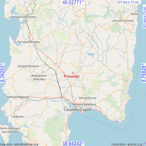
Pimentel GPS coordinates[2]
39° 29' 13.848" North, 9° 3' 54.576" East
| Map corner | latitude | longitude |
|---|---|---|
| Upper-left | 40.02771°, | 8.36203° |
| Center: | 39.48718°, | 9.06516° |
| Lower-right: | 38.94242°, | 9.76828° |
| Map W x H: | 120.7×120.7 km | = 75×75mi |
| max Lat: | 47.04031° ⇑90.4% North |
| Pimentel: | 39.48718° |
| min Lat: | ⇓9.6% South 35.50142° |
| min Long | Pimentel | max Long |
| 6.69888° | 9.06516° | 18.48682° |
| W 19.7%⇐ | ⇒80.3% E |
Elevation
Elevation of Pimentel is 155 m = 509 ft, and this is 151.7 m = 498 ft below average elevation for this country.
| Max E: |
2085 m = 6841 ft | 61% |
| Avg. | 306.7 m = 1006 ft | |
| Pimentel | 155 m = 509 ft | |
Min E: |
-4 m = -13 ft | 39% |
See also: Italy elevation on elevation.city.
Geographical zone
Pimentel is located in North temperate zone (between Tropic of Cancer and the Arctic Circle). Distance of this Northern Tropic circle is 1784.6 km =1108.9 mi to South.| Distance of | km | miles | from Pimentel |
|---|---|---|---|
| North Pole | 5616.5 | 3489.9 | to North |
| Arctic Circle | 3010.6 | 1870.7 | to North |
| Tropic Cancer | 1784.6 | 1108.9 | to South |
| Equator | 4390.6 | 2728.2 | to South |


Nearby cities:
15 places around Pimentel: (largest is in red/bold)
• Barrali
3.4 km =2.1 mi,  112°
112°
• Donorì
8.1 km =5 mi,  139°
139°
• Guamaggiore
9.1 km =5.7 mi,  4°
4°
• Guasila
8.3 km =5.2 mi,  347°
347°
• Monastir
11.7 km =7.3 mi,  188°
188°
• Nuraminis
6.6 km =4.1 mi,  221°
221°
• Ortacesus
6.1 km =3.8 mi,  17°
17°
• Samatzai
2.7 km =1.7 mi,  259°
259°
• Sant'Andrea Frius
9 km =5.6 mi,  95°
95°
• Segariu
11.2 km =7 mi,  320°
320°
• Selegas
9.5 km =5.9 mi, 20°
• Senorbì
7.7 km =4.8 mi,  47°
47°
• Serrenti
7.6 km =4.7 mi,  274°
274°
• Suelli
10.2 km =6.3 mi,  34°
34°
• Ussana
10.4 km =6.5 mi,  175°
175°
Sources, notices
• [Note1] Compared only with cities in Italy existing in our database
• [Src1] Map data: © OpenStreetMap contributors (CC-BY-SA)
• [Src2] Other city data from geonames.org with taken over terms of usage.
• [Src3] Geographical zone / Annual Mean Temperature by Robert A. Rohde @ Wikipedia
