Ugento geodata
Ugento (Apulia) is a seat of a third-order administrative division; located in Italy in Europe/Rome (GMT+2) time zone. With population of 8,875 people, there are 1075 cities with bigger population in this country. Compared to other cities in Italy, 88.5% of cities are located further ↑North; 99.2% of cities are located further ←West and 71.6% of cities have higher elevation than Ugento. Note1


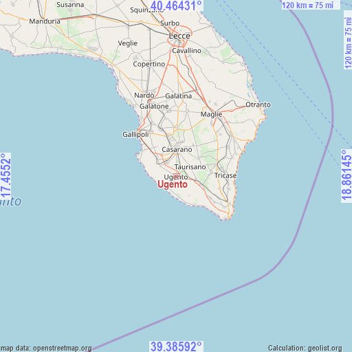
Ugento GPS coordinates[2]
39° 55' 38.064" North, 18° 9' 29.952" East
| Map corner | latitude | longitude |
|---|---|---|
| Upper-left | 40.46431°, | 17.4552° |
| Center: | 39.92724°, | 18.15832° |
| Lower-right: | 39.38592°, | 18.86145° |
| Map W x H: | 119.9×119.9 km | = 74.5×74.5mi |
| max Lat: | 47.04031° ⇑88.5% North |
| Ugento: | 39.92724° |
| min Lat: | ⇓11.5% South 35.50142° |
| min Long | Ugento | max Long |
| 6.69888° | 18.15832° | 18.48682° |
| W 99.2%⇐ | ⇒0.8% E |
Elevation
Elevation of Ugento is 89 m = 292 ft, and this is 217.7 m = 714 ft below average elevation for this country.
| Max E: |
2085 m = 6841 ft | 71.6% |
| Avg. | 306.7 m = 1006 ft | |
| Ugento | 89 m = 292 ft | |
Min E: |
-4 m = -13 ft | 28.4% |
See also: Italy elevation on elevation.city.
Geographical zone
Ugento is located in North temperate zone (between Tropic of Cancer and the Arctic Circle). Distance of this Northern Tropic circle is 1833.6 km =1139.3 mi to South.| Distance of | km | miles | from Ugento |
|---|---|---|---|
| North Pole | 5567.6 | 3459.5 | to North |
| Arctic Circle | 2961.7 | 1840.3 | to North |
| Tropic Cancer | 1833.6 | 1139.3 | to South |
| Equator | 4439.5 | 2758.6 | to South |


Nearby cities:
15 places around Ugento: (largest is in red/bold)
• Acquarica del Capo
7.8 km =4.8 mi,  104°
104°
• Alliste
6.3 km =3.9 mi,  291°
291°
• Casarano
9.4 km =5.8 mi,  2°
2°
• Felline
3.6 km =2.2 mi, 286°
• Gemini
3 km =1.9 mi,  125°
125°
• Matino
11.7 km =7.3 mi,  350°
350°
• Melissano
6 km =3.7 mi,  328°
328°
• Presicce
9.4 km =5.8 mi,  108°
108°
• Racale
6.8 km =4.2 mi,  303°
303°
• Ruffano
9.9 km =6.2 mi,  52°
52°
• Specchia
12 km =7.5 mi,  83°
83°
• Taurisano
5.9 km =3.7 mi,  55°
55°
• Taviano
9 km =5.6 mi,  313°
313°
• Torre San Giovanni
5.7 km =3.5 mi,  223°
223°
• Torre Suda
11.1 km =6.9 mi, 286°
Sources, notices
• [Note1] Compared only with cities in Italy existing in our database
• [Src1] Map data: © OpenStreetMap contributors (CC-BY-SA)
• [Src2] Other city data from geonames.org with taken over terms of usage.
• [Src3] Geographical zone / Annual Mean Temperature by Robert A. Rohde @ Wikipedia
