Ruffano geodata
Ruffano (Apulia) is a seat of a third-order administrative division; located in Italy in Europe/Rome (GMT+2) time zone. With population of 9,091 people, there are 1040 cities with bigger population in this country. Compared to other cities in Italy, 88.1% of cities are located further ↑North; 99.4% of cities are located further ←West and 68% of cities have higher elevation than Ruffano. Note1


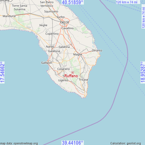
Ruffano GPS coordinates[2]
39° 58' 55.02" North, 18° 14' 59.064" East
| Map corner | latitude | longitude |
|---|---|---|
| Upper-left | 40.51859°, | 17.54662° |
| Center: | 39.98195°, | 18.24974° |
| Lower-right: | 39.44106°, | 18.95287° |
| Map W x H: | 119.8×119.8 km | = 74.4×74.4mi |
| max Lat: | 47.04031° ⇑88.1% North |
| Ruffano: | 39.98195° |
| min Lat: | ⇓11.9% South 35.50142° |
| min Long | Ruffano | max Long |
| 6.69888° | 18.24974° | 18.48682° |
| W 99.4%⇐ | ⇒0.59999999999999% E |
Elevation
Elevation of Ruffano is 109 m = 358 ft, and this is 197.7 m = 649 ft below average elevation for this country.
| Max E: |
2085 m = 6841 ft | 68% |
| Avg. | 306.7 m = 1006 ft | |
| Ruffano | 109 m = 358 ft | |
Min E: |
-4 m = -13 ft | 32% |
See also: Italy elevation on elevation.city.
Geographical zone
Ruffano is located in North temperate zone (between Tropic of Cancer and the Arctic Circle). Distance of this Northern Tropic circle is 1839.7 km =1143.1 mi to South.| Distance of | km | miles | from Ruffano |
|---|---|---|---|
| North Pole | 5561.5 | 3455.8 | to North |
| Arctic Circle | 2955.6 | 1836.5 | to North |
| Tropic Cancer | 1839.7 | 1143.1 | to South |
| Equator | 4445.6 | 2762.4 | to South |


Nearby cities:
15 places around Ruffano: (largest is in red/bold)
• Acquarica del Capo
8 km =5 mi,  181°
181°
• Casarano
8.1 km =5 mi,  293°
293°
• Castiglione
8.5 km =5.3 mi,  88°
88°
• Depressa
9.9 km =6.2 mi,  104°
104°
• Gemini
9.5 km =5.9 mi,  214°
214°
• Lucugnano
8.1 km =5 mi,  130°
130°
• Miggiano
5.7 km =3.5 mi,  113°
113°
• Montesano Salentino
6.3 km =3.9 mi, 96°
• Nociglia
9.1 km =5.7 mi,  46°
46°
• Presicce
9.1 km =5.7 mi,  172°
172°
• Specchia
6.3 km =3.9 mi,  139°
139°
• Supersano
3.9 km =2.4 mi,  350°
350°
• Surano
9.7 km =6 mi,  57°
57°
• Taurisano
4 km =2.5 mi,  227°
227°
• Ugento
9.9 km =6.2 mi, 232°
Sources, notices
• [Note1] Compared only with cities in Italy existing in our database
• [Src1] Map data: © OpenStreetMap contributors (CC-BY-SA)
• [Src2] Other city data from geonames.org with taken over terms of usage.
• [Src3] Geographical zone / Annual Mean Temperature by Robert A. Rohde @ Wikipedia
