Serrata geodata
Serrata (Calabria) is a seat of a third-order administrative division; located in Italy in Europe/Rome (GMT+2) time zone. With population of 914 people, there are 7072 cities with bigger population in this country. Compared to other cities in Italy, 94.1% of cities are located further ↑North; 93.6% of cities are located further ←West and 57.9% of cities have lower elevation than Serrata. Note1
Administrative division(s):
- Level 1: Calabria
- Level 2: Provincia di Reggio Calabria
- Level 3: Serrata


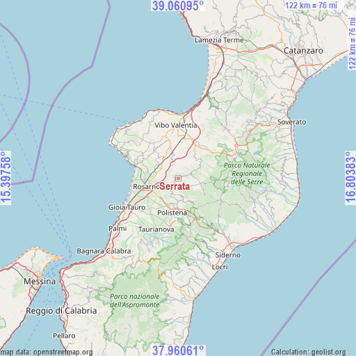
Serrata GPS coordinates[2]
38° 30' 46.368" North, 16° 6' 2.52" East
| Map corner | latitude | longitude |
|---|---|---|
| Upper-left | 39.06095°, | 15.39758° |
| Center: | 38.51288°, | 16.1007° |
| Lower-right: | 37.96061°, | 16.80383° |
| Map W x H: | 122.3×122.3 km | = 76×76mi |
| max Lat: | 47.04031° ⇑94.1% North |
| Serrata: | 38.51288° |
| min Lat: | ⇓5.9% South 35.50142° |
| min Long | Serrata | max Long |
| 6.69888° | 16.1007° | 18.48682° |
| W 93.6%⇐ | ⇒6.4% E |
Elevation
Elevation of Serrata is 285 m = 935 ft, and this is 21.7 m = 71 ft below average elevation for this country.
| Max E: |
2085 m = 6841 ft | 42.1% |
| Avg. | 306.7 m = 1006 ft | |
| Serrata | 285 m = 935 ft | |
Min E: |
-4 m = -13 ft | 57.9% |
See also: Italy elevation on elevation.city.
Geographical zone
Serrata is located in North temperate zone (between Tropic of Cancer and the Arctic Circle). Distance of this Northern Tropic circle is 1676.3 km =1041.6 mi to South.| Distance of | km | miles | from Serrata |
|---|---|---|---|
| North Pole | 5724.8 | 3557.2 | to North |
| Arctic Circle | 3118.9 | 1938 | to North |
| Tropic Cancer | 1676.3 | 1041.6 | to South |
| Equator | 4282.2 | 2660.8 | to South |


Nearby cities:
15 places around Serrata: (largest is in red/bold)
• Acquaro
9 km =5.6 mi,  56°
56°
• Anoia Inferiore
8.7 km =5.4 mi,  192°
192°
• Anoia Superiore
9.1 km =5.7 mi,  181°
181°
• Calimera
8.8 km =5.5 mi,  302°
302°
• Candidoni
1.5 km =0.9 mi,  236°
236°
• Dinami
4.3 km =2.7 mi, 61°
• Feroleto della Chiesa
5.8 km =3.6 mi,  207°
207°
• Galatro
5.8 km =3.6 mi,  173°
173°
• Giffone
9.2 km =5.7 mi,  152°
152°
• Laureana di Borrello
2.7 km =1.7 mi, 211°
• Maropati
7.9 km =4.9 mi, 182°
• Melicuccà
5.6 km =3.5 mi, 61°
• Monsoreto
5.7 km =3.5 mi,  87°
87°
• San Pietro di Caridà
3.2 km =2 mi,  68°
68°
• Tritanti
7.1 km =4.4 mi, 179°
Sources, notices
• [Note1] Compared only with cities in Italy existing in our database
• [Src1] Map data: © OpenStreetMap contributors (CC-BY-SA)
• [Src2] Other city data from geonames.org with taken over terms of usage.
• [Src3] Geographical zone / Annual Mean Temperature by Robert A. Rohde @ Wikipedia
