Tiggiano geodata
Tiggiano (Apulia) is a seat of a third-order administrative division; located in Italy in Europe/Rome (GMT+2) time zone. With population of 2,822 people, there are 3192 cities with bigger population in this country. Compared to other cities in Italy, 88.6% of cities are located further ↑North; 99.8% of cities are located further ←West and 64.6% of cities have higher elevation than Tiggiano. Note1


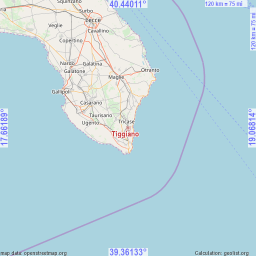
Tiggiano GPS coordinates[2]
39° 54' 10.224" North, 18° 21' 54.036" East
| Map corner | latitude | longitude |
|---|---|---|
| Upper-left | 40.44011°, | 17.66189° |
| Center: | 39.90284°, | 18.36501° |
| Lower-right: | 39.36133°, | 19.06814° |
| Map W x H: | 119.9×119.9 km | = 74.5×74.5mi |
| max Lat: | 47.04031° ⇑88.6% North |
| Tiggiano: | 39.90284° |
| min Lat: | ⇓11.4% South 35.50142° |
| min Long | Tiggiano | max Long |
| 6.69888° | 18.36501° | 18.48682° |
| W 99.8%⇐ | ⇒0.2% E |
Elevation
Elevation of Tiggiano is 130 m = 427 ft, and this is 176.7 m = 580 ft below average elevation for this country.
| Max E: |
2085 m = 6841 ft | 64.6% |
| Avg. | 306.7 m = 1006 ft | |
| Tiggiano | 130 m = 427 ft | |
Min E: |
-4 m = -13 ft | 35.4% |
See also: Italy elevation on elevation.city.
Geographical zone
Tiggiano is located in North temperate zone (between Tropic of Cancer and the Arctic Circle). Distance of this Northern Tropic circle is 1830.9 km =1137.7 mi to South.| Distance of | km | miles | from Tiggiano |
|---|---|---|---|
| North Pole | 5570.3 | 3461.2 | to North |
| Arctic Circle | 2964.4 | 1842 | to North |
| Tropic Cancer | 1830.9 | 1137.7 | to South |
| Equator | 4436.8 | 2756.9 | to South |


Nearby cities:
15 places around Tiggiano: (largest is in red/bold)
• Alessano
3 km =1.9 mi,  250°
250°
• Barbarano del Capo
5.4 km =3.4 mi,  216°
216°
• Castrignano del Capo
7.9 km =4.9 mi,  188°
188°
• Corsano
1.5 km =0.9 mi,  172°
172°
• Depressa
6.3 km =3.9 mi,  357°
357°
• Gagliano del Capo
6.6 km =4.1 mi,  176°
176°
• Giuliano
6.5 km =4 mi,  201°
201°
• Lucugnano
5.1 km =3.2 mi,  314°
314°
• Montesardo
3.7 km =2.3 mi, 215°
• Morciano di Leuca
7.7 km =4.8 mi, 216°
• Patù
7.3 km =4.5 mi, 198°
• Ruggiano
5.6 km =3.5 mi,  229°
229°
• Salve
7.6 km =4.7 mi, 232°
• Specchia
7 km =4.3 mi, 305°
• Tricase
3.2 km =2 mi,  343°
343°
Sources, notices
• [Note1] Compared only with cities in Italy existing in our database
• [Src1] Map data: © OpenStreetMap contributors (CC-BY-SA)
• [Src2] Other city data from geonames.org with taken over terms of usage.
• [Src3] Geographical zone / Annual Mean Temperature by Robert A. Rohde @ Wikipedia
