Depressa geodata
Depressa (Apulia) is a populated place; located in Italy in Europe/Rome (GMT+2) time zone. With population of 1,503 people, there are 5111 cities with bigger population in this country. Compared to other cities in Italy, 88.2% of cities are located further ↑North; 99.8% of cities are located further ←West and 68.6% of cities have higher elevation than Depressa. Note1


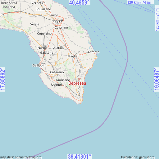
Depressa GPS coordinates[2]
39° 57' 32.688" North, 18° 21' 42.264" East
| Map corner | latitude | longitude |
|---|---|---|
| Upper-left | 40.4959°, | 17.65862° |
| Center: | 39.95908°, | 18.36174° |
| Lower-right: | 39.41801°, | 19.06487° |
| Map W x H: | 119.9×119.8 km | = 74.5×74.4mi |
| max Lat: | 47.04031° ⇑88.2% North |
| Depressa: | 39.95908° |
| min Lat: | ⇓11.8% South 35.50142° |
| min Long | Depressa | max Long |
| 6.69888° | 18.36174° | 18.48682° |
| W 99.8%⇐ | ⇒0.2% E |
Elevation
Elevation of Depressa is 105 m = 344 ft, and this is 201.7 m = 662 ft below average elevation for this country.
| Max E: |
2085 m = 6841 ft | 68.6% |
| Avg. | 306.7 m = 1006 ft | |
| Depressa | 105 m = 344 ft | |
Min E: |
-4 m = -13 ft | 31.4% |
See also: Italy elevation on elevation.city.
Geographical zone
Depressa is located in North temperate zone (between Tropic of Cancer and the Arctic Circle). Distance of this Northern Tropic circle is 1837.1 km =1141.5 mi to South.| Distance of | km | miles | from Depressa |
|---|---|---|---|
| North Pole | 5564 | 3457.3 | to North |
| Arctic Circle | 2958.1 | 1838.1 | to North |
| Tropic Cancer | 1837.1 | 1141.5 | to South |
| Equator | 4443 | 2760.8 | to South |


Nearby cities:
15 places around Depressa: (largest is in red/bold)
• Alessano
7.7 km =4.8 mi,  199°
199°
• Andrano
3.4 km =2.1 mi,  30°
30°
• Castiglione
2.9 km =1.8 mi,  339°
339°
• Castro
7.6 km =4.7 mi,  45°
45°
• Corsano
7.8 km =4.8 mi,  176°
176°
• Diso
6.1 km =3.8 mi,  24°
24°
• Lucugnano
4.3 km =2.7 mi,  231°
231°
• Marittima
5.2 km =3.2 mi,  37°
37°
• Miggiano
4.3 km =2.7 mi,  274°
274°
• Montesano Salentino
3.8 km =2.4 mi,  298°
298°
• Specchia
5.9 km =3.7 mi,  247°
247°
• Spongano
6.5 km =4 mi,  2°
2°
• Tiggiano
6.3 km =3.9 mi, 177°
• Tricase
3.3 km =2.1 mi,  191°
191°
• Vignacastrisi
7.4 km =4.6 mi, 31°
Sources, notices
• [Note1] Compared only with cities in Italy existing in our database
• [Src1] Map data: © OpenStreetMap contributors (CC-BY-SA)
• [Src2] Other city data from geonames.org with taken over terms of usage.
• [Src3] Geographical zone / Annual Mean Temperature by Robert A. Rohde @ Wikipedia
