Sommatino geodata
Sommatino (Sicily) is a seat of a third-order administrative division; located in Italy in Europe/Rome (GMT+2) time zone. With population of 6,934 people, there are 1408 cities with bigger population in this country. Compared to other cities in Italy, 99.2% of cities are located further ↑North; 78.2% of cities are located further ←West and 67.4% of cities have lower elevation than Sommatino. Note1


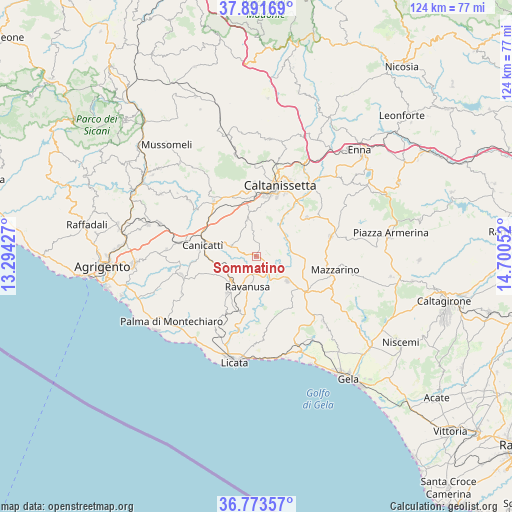
Sommatino GPS coordinates[2]
37° 20' 4.956" North, 13° 59' 50.604" East
| Map corner | latitude | longitude |
|---|---|---|
| Upper-left | 37.89169°, | 13.29427° |
| Center: | 37.33471°, | 13.99739° |
| Lower-right: | 36.77357°, | 14.70052° |
| Map W x H: | 124.3×124.3 km | = 77.2×77.2mi |
| max Lat: | 47.04031° ⇑99.2% North |
| Sommatino: | 37.33471° |
| min Lat: | ⇓0.8% South 35.50142° |
| min Long | Sommatino | max Long |
| 6.69888° | 13.99739° | 18.48682° |
| W 78.2%⇐ | ⇒21.8% E |
Elevation
Elevation of Sommatino is 367 m = 1204 ft, and this is 60.3 m = 198 ft above average elevation for this country.
| Max E: |
2085 m = 6841 ft | 32.6% |
| Sommatino | 367 m 1204 ft | |
| Avg. | 306.7 m = 1006 ft | |
Min E: |
-4 m = -13 ft | 67.4% |
See also: Italy elevation on elevation.city.
Geographical zone
Sommatino is located in North temperate zone (between Tropic of Cancer and the Arctic Circle). Distance of this Northern Tropic circle is 1545.3 km =960.2 mi to South.| Distance of | km | miles | from Sommatino |
|---|---|---|---|
| North Pole | 5855.8 | 3638.6 | to North |
| Arctic Circle | 3249.9 | 2019.4 | to North |
| Tropic Cancer | 1545.3 | 960.2 | to South |
| Equator | 4151.2 | 2579.4 | to South |


Nearby cities:
15 places around Sommatino: (largest is in red/bold)
• Barrafranca
18.8 km =11.7 mi,  74°
74°
• Caltanissetta
18.2 km =11.3 mi,  18°
18°
• Camastra
20.3 km =12.6 mi,  243°
243°
• Campobello di Licata
11.1 km =6.9 mi,  219°
219°
• Canicattì
13.5 km =8.4 mi,  281°
281°
• Castrofilippo
21.9 km =13.6 mi,  274°
274°
• Delia
6.6 km =4.1 mi,  293°
293°
• Mazzarino
19.1 km =11.9 mi,  101°
101°
• Montedoro
20.8 km =12.9 mi,  309°
309°
• Naro
18.6 km =11.6 mi,  255°
255°
• Pietraperzia
15.5 km =9.6 mi,  53°
53°
• Ravanusa
8 km =5 mi,  198°
198°
• Riesi
9.7 km =6 mi,  128°
128°
• San Cataldo
16.6 km =10.3 mi,  356°
356°
• Serradifalco
16.8 km =10.4 mi,  322°
322°
Sources, notices
• [Note1] Compared only with cities in Italy existing in our database
• [Src1] Map data: © OpenStreetMap contributors (CC-BY-SA)
• [Src2] Other city data from geonames.org with taken over terms of usage.
• [Src3] Geographical zone / Annual Mean Temperature by Robert A. Rohde @ Wikipedia
