Ravanusa geodata
Ravanusa (Sicily) is a seat of a third-order administrative division; located in Italy in Europe/Rome (GMT+2) time zone. With population of 12,051 people, there are 770 cities with bigger population in this country. Compared to other cities in Italy, 99.4% of cities are located further ↑North; 78% of cities are located further ←West and 62.3% of cities have lower elevation than Ravanusa. Note1


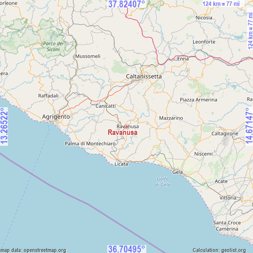
Ravanusa GPS coordinates[2]
37° 15' 59.724" North, 13° 58' 6.024" East
| Map corner | latitude | longitude |
|---|---|---|
| Upper-left | 37.82407°, | 13.26522° |
| Center: | 37.26659°, | 13.96834° |
| Lower-right: | 36.70495°, | 14.67147° |
| Map W x H: | 124.4×124.4 km | = 77.3×77.3mi |
| max Lat: | 47.04031° ⇑99.4% North |
| Ravanusa: | 37.26659° |
| min Lat: | ⇓0.6% South 35.50142° |
| min Long | Ravanusa | max Long |
| 6.69888° | 13.96834° | 18.48682° |
| W 78%⇐ | ⇒22% E |
Elevation
Elevation of Ravanusa is 317 m = 1040 ft, and this is 10.3 m = 34 ft above average elevation for this country.
| Max E: |
2085 m = 6841 ft | 37.7% |
| Ravanusa | 317 m 1040 ft | |
| Avg. | 306.7 m = 1006 ft | |
Min E: |
-4 m = -13 ft | 62.3% |
See also: Italy elevation on elevation.city.
Geographical zone
Ravanusa is located in North temperate zone (between Tropic of Cancer and the Arctic Circle). Distance of this Northern Tropic circle is 1537.7 km =955.5 mi to South.| Distance of | km | miles | from Ravanusa |
|---|---|---|---|
| North Pole | 5863.4 | 3643.3 | to North |
| Arctic Circle | 3257.5 | 2024.1 | to North |
| Tropic Cancer | 1537.7 | 955.5 | to South |
| Equator | 4143.7 | 2574.8 | to South |


Nearby cities:
15 places around Ravanusa: (largest is in red/bold)
• Butera
20.7 km =12.9 mi,  113°
113°
• Camastra
15.7 km =9.8 mi,  264°
264°
• Campobello di Licata
4.6 km =2.9 mi, 257°
• Canicattì
14.8 km =9.2 mi,  313°
313°
• Castrofilippo
21.4 km =13.3 mi,  295°
295°
• Delia
10.7 km =6.6 mi,  340°
340°
• Licata
18.4 km =11.4 mi,  187°
187°
• Mazzarino
21.7 km =13.5 mi,  79°
79°
• Naro
15.7 km =9.8 mi,  280°
280°
• Palma di Montechiaro
19.8 km =12.3 mi,  244°
244°
• Pietraperzia
22.6 km =14 mi,  41°
41°
• Riesi
10.3 km =6.4 mi, 81°
• San Cataldo
24.2 km =15 mi,  3°
3°
• Serradifalco
22.2 km =13.8 mi, 339°
• Sommatino
8 km =5 mi,  18°
18°
Sources, notices
• [Note1] Compared only with cities in Italy existing in our database
• [Src1] Map data: © OpenStreetMap contributors (CC-BY-SA)
• [Src2] Other city data from geonames.org with taken over terms of usage.
• [Src3] Geographical zone / Annual Mean Temperature by Robert A. Rohde @ Wikipedia
