Delia geodata
Delia (Sicily) is a seat of a third-order administrative division; located in Italy in Europe/Rome (GMT+2) time zone. With population of 4,191 people, there are 2287 cities with bigger population in this country. Compared to other cities in Italy, 99.2% of cities are located further ↑North; 77.7% of cities are located further ←West and 73.9% of cities have lower elevation than Delia. Note1


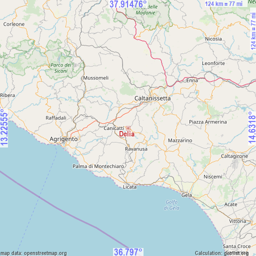
Delia GPS coordinates[2]
37° 21' 28.656" North, 13° 55' 43.212" East
| Map corner | latitude | longitude |
|---|---|---|
| Upper-left | 37.91476°, | 13.22555° |
| Center: | 37.35796°, | 13.92867° |
| Lower-right: | 36.797°, | 14.6318° |
| Map W x H: | 124.3×124.3 km | = 77.2×77.2mi |
| max Lat: | 47.04031° ⇑99.2% North |
| Delia: | 37.35796° |
| min Lat: | ⇓0.8% South 35.50142° |
| min Long | Delia | max Long |
| 6.69888° | 13.92867° | 18.48682° |
| W 77.7%⇐ | ⇒22.3% E |
Elevation
Elevation of Delia is 438 m = 1437 ft, and this is 131.3 m = 431 ft above average elevation for this country.
| Max E: |
2085 m = 6841 ft | 26.1% |
| Delia | 438 m 1437 ft | |
| Avg. | 306.7 m = 1006 ft | |
Min E: |
-4 m = -13 ft | 73.9% |
See also: Italy elevation on elevation.city.
Geographical zone
Delia is located in North temperate zone (between Tropic of Cancer and the Arctic Circle). Distance of this Northern Tropic circle is 1547.9 km =961.8 mi to South.| Distance of | km | miles | from Delia |
|---|---|---|---|
| North Pole | 5853.2 | 3637 | to North |
| Arctic Circle | 3247.4 | 2017.8 | to North |
| Tropic Cancer | 1547.9 | 961.8 | to South |
| Equator | 4153.8 | 2581.1 | to South |


Nearby cities:
15 places around Delia: (largest is in red/bold)
• Bompensiere
18.2 km =11.3 mi,  314°
314°
• Caltanissetta
18.8 km =11.7 mi,  38°
38°
• Camastra
16.7 km =10.4 mi,  226°
226°
• Campobello di Licata
11.2 km =7 mi,  184°
184°
• Canicattì
7.1 km =4.4 mi,  270°
270°
• Castrofilippo
15.8 km =9.8 mi, 266°
• Montedoro
14.6 km =9.1 mi,  317°
317°
• Naro
14 km =8.7 mi,  238°
238°
• Pietraperzia
19.6 km =12.2 mi,  69°
69°
• Racalmuto
18.3 km =11.4 mi,  286°
286°
• Ravanusa
10.7 km =6.6 mi,  160°
160°
• Riesi
16.1 km =10 mi,  122°
122°
• San Cataldo
14.9 km =9.3 mi,  19°
19°
• Serradifalco
11.5 km =7.1 mi,  338°
338°
• Sommatino
6.6 km =4.1 mi,  113°
113°
Sources, notices
• [Note1] Compared only with cities in Italy existing in our database
• [Src1] Map data: © OpenStreetMap contributors (CC-BY-SA)
• [Src2] Other city data from geonames.org with taken over terms of usage.
• [Src3] Geographical zone / Annual Mean Temperature by Robert A. Rohde @ Wikipedia
